
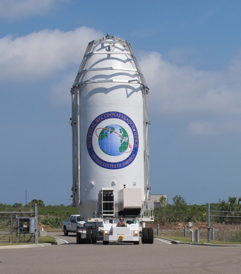
Identifying the classified NROL-76 Satellite

The United States National Reconnaissance Office is an intelligence agency tasked with the design, construction and operation of all U.S. reconnaissance satellites and delivers satellite intelligence to other intelligence agencies including signals intelligence for the NSA, image reconnaissance data to the NGA and measurement & signature intelligence to the DIA. Established in 1961, the NRO has been shrouded in great secrecy and its existence as an agency was only first acknowledged in the early 1990s.
As an intelligence agency, the NRO goes through great lengths to keep its activities secret, therefore the identity of all NRO satellites is classified. However, it is possible to identify the nature of satellites taking into account their launch site, launch window, launch vehicle type and ascent path. Sometimes, hints can be found in mission logos and, after launch, most satellites are typically tracked in orbit by a worldwide network of observers, revealing from where they operate, and often what they are tasked with.
Some cases are easier to solve while other NRO missions can only be narrowed down to a number of candidates. NROL-76 is a harder nut to crack for a number of reasons outlined below.
The NROL-76 launch contract with SpaceX was first revealed by the NRO in 2016, but was awarded as early as mid-2012 or 13 according to comments made by NRO officials. At that point, SpaceX was in the midst of its transition from the Falcon 9 v1.0 to the much-improved v1.1 version. NROL-76 was most likely sized for the v1.1 version of Falcon 9, providing an upper limit of 4,850kg if headed to GTO and 10,890kg if headed to LEO based on the rocket’s performance numbers.
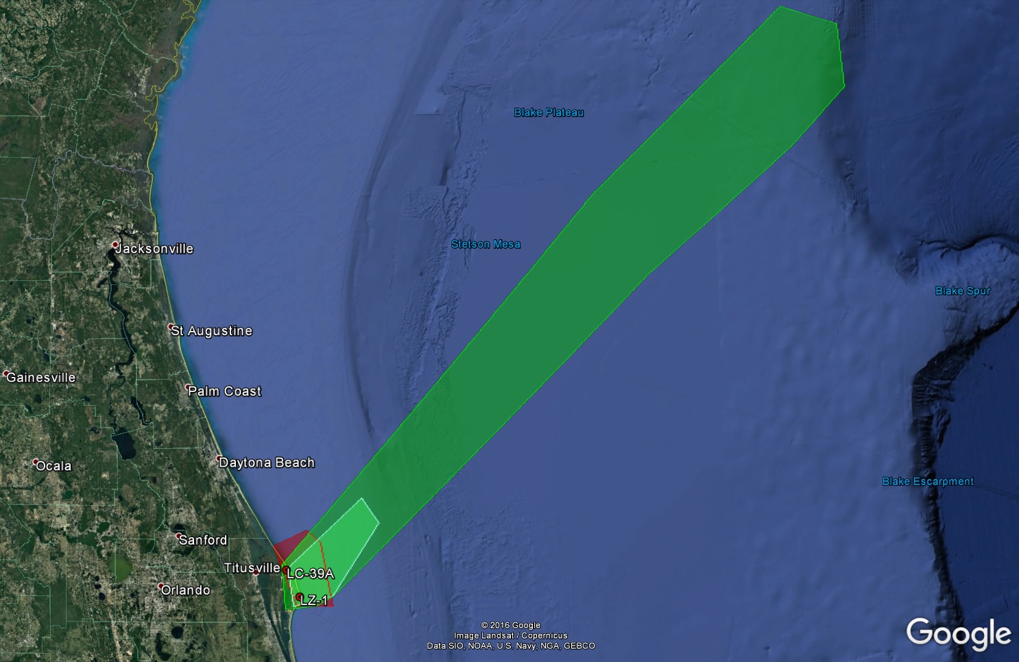
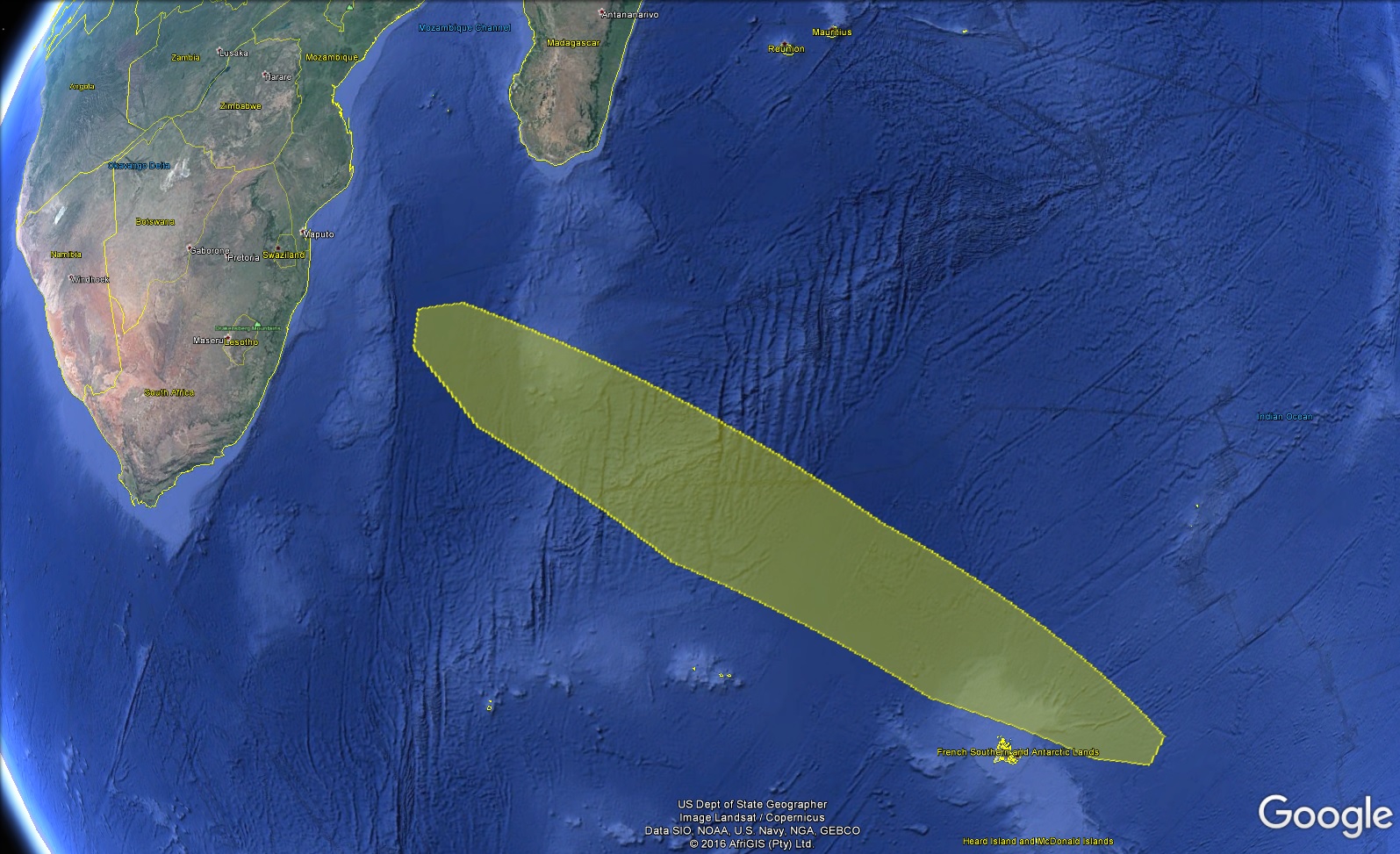
The most valuable clue for this mission is found in the launch hazard areas that reveal the orbital inclination this mission is headed to. Two safety areas have been identified through the typical NOTAMs (Notices to Airmen and Mariners), the first corresponding to the direct launch corridor out of Kennedy Space Center and another south east of South Africa, likely corresponding to the deorbit of the second stage.
To deliver NROL-76, Falcon 9 will depart Florida to the north-east – ruling out a Geostationary Mission. Still in play are a LEO Mission and a highly-elliptical Molniya Orbit that is used for reconnaissance and communications assets that need to cover the high-latitude regions in the north.
It has been disclosed that the NROL-76 mission would feature a first stage RTLS (Return to Launch Site) for recovery, indicating Falcon 9 has plenty of performance margin, either carrying a very light payload or targeting a low-energy orbit (or a combination of the two). Performance wise, Falcon 9 FT could deliver 2,300 Kilograms into a Molniya Transfer Orbit and still manage an RTLS landing while LEO capability with RTLS is on the order of 10.5 metric tons. This still leaves a number of options on the table.
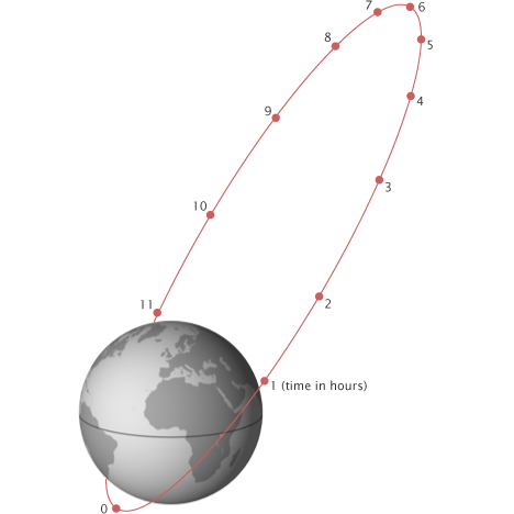
Molniya Orbit is a characteristic orbit named after the Soviet/Russian Molniya communications satellites that used this type of orbit since the 1960s to optimize coverage for Russia’s high-latitude regions. Molniya Orbits are characterized by a period of half a sidereal day (11 hrs & 56 min) and an inclination of 63.4 or 116.6 degrees which allows a satellite to have a constant argument of perigee and avoid perturbations by the gravitational field of Earth. Relative to Earth, the satellite’s speed is slowest at higher altitudes, meaning that the spacecraft spends the majority of its time around apogee, i.e. the northern hemisphere.
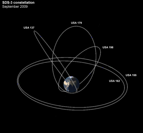
Typically, Molniya orbits are used for communications in the high-latitude regions, meteorology satellites and missile-warning satellites tasked with covering the northern sector that can not be easily viewed from Geostationary Orbit. If indeed heading for Molniya Orbit, NROL-76, in all likelihood, is a member of the fourth generation of the Satellite Data System (SDS).
SDS, also known under the code name Quasar, operates relay satellites in Geostationary and Molniya Orbits to provide real-time downlink of imagery from low-orbiting reconnaissance satellites, notably the Keyhole electro-optical reconnaissance satellites and Lacrosse/Topaz radar assets. The SDS constellation typically consisted of at least two satellites in Geostationary Orbit and three in Molniya Orbits at the proper spacing to allow each to be over the northern hemisphere for eight hours to create 24/7 coverage.
The first generation of SDS began deployment in 1976 and saw seven launches through 1987, employing 630-Kilogram satellites that offered twelve channels for UHF communications. The SDS-2 satellites, four of which were launched between 1989 and 1996, were more massive with a launch mass of 2.3 metric tons and the addition of K-Band downlink capability. SDS-3 debuted in 1998 and used Atlas V and Delta IV launch vehicles to lift eight satellites through the year 2014.
The first SDS-4 satellite is rumored to be the NROL-61 payload (USA-269) launched in July 2016 and taking up residence in Geostationary Orbit. The last SDS satellite launched into Molniya Orbit was NROL-24 in 2007, causing speculation that SDS may be transitioning to a purely GEO-based system.
If the Molniya Segment of the constellation is to be continued, a replacement for one of the aging satellites would have to go up soon as previous SDS satellites have shown a nominal replacement rate of around a decade.
The SDS satellites were reportedly manufactured by Hughes Space & Communications, now part of Boeing’s Satellite Development Center. The latest Geostationary SDS satellite used the Atlas V 421 launch vehicle, indicating a mass of slightly over five metric tons consistent with Boeing’s BSS-702HP high-power satellite bus suitable for powerful communications satellites.

NROL-76, if indeed headed to Molniya orbit, could not use the 702HP version and would instead have to use the 702SP all-electric satellite that comes with a launch mass between 1,900 and 2,300 Kilograms (right in the performance range for Falcon 9 with RTLS).
Boeing received three orders from the U.S. Government in 2013 for 702SP satellites with no information on the programs these satellites would belong to. The procurement of SpaceX’s Falcon 9 for the NROL-76 mission coincides with the timing of the Boeing order, adding merit to this being an SDS satellite. In a contrary statement, the NRO said NROL-76 was ‘designed, built and operated’ by the NRO itself – however, this phrase has been used in the past when generally describing the NRO’s tasks.
The palette of LEO missions for NROL-76 is much larger than for the highly specialized Molniya Orbit. However, some options such as planar missions and existing NRO constellations can be ruled out because the launch time for NROL-76 was not affected by the two-week delay from a mid- to a late April 2017 launch. Planar windows shift by several minutes per day as would constellation missions, indicating NROL-76 – if headed to LEO – is likely a one-off or experimental mission targeting a non-synchronous orbit.

According to official NRO information, the agency did not directly book a ride with SpaceX but contracted with Ball Aerospace which then secured the Falcon 9 launch vehicle. This is indicative of a ‘delivery in orbit’ type of contract which would make Ball Aerospace the manufacturer of the NROL-76 satellite.
To date, Ball Aerospace has built a reputation for optical instrumentation carried by Earth-orbiting satellites and interplanetary spacecraft, as well as a number of small- and medium-class satellites. The largest satellite platform offered by Ball Aerospace is the BCP-5000 that can carry sizeable payloads and has been optimized for Earth-observation missions. BCP-4000 is similarly massive, but optimized for Synthetic Aperture Radar instruments.
WorldView-3 is the biggest satellite manufactured by Ball, weighing in at 2,800 Kilograms. NROL-76 is likely in a similar mass range, giving Falcon 9 plenty of excess performance for the first stage return to Landing Zone-1 and the second stage deorbit maneuver.
One option, raised by satellite tracking expert Ted Molczan, is NROL-76 as a replacement for USA-193 that launched as NROL-21 atop a Delta II rocket in December 2006. The radar reconnaissance satellite entered an orbit of 350 by 365 Kilometers, 58.5° but failed shortly after launch.

By February 2008, the satellite had decayed to 242 by 257 Kilometers and plans were set in motion to purposefully destroy the spacecraft to dissipate over 450kg of hazardous propellant and prevent pieces that could survive re-entry from reaching the ground.
USA-193 was intercepted by an SM-3 missile on February 21, 2008 which successfully destroyed the 2,300-Kilogram craft into 174 trackable debris most of which re-entered within a few days of the event while others lingered in orbit for another year and a half.
It is questionable whether the framework under which USA-193 was created is still in existence. The mission was developed under the NRO’s Future Imagery Architecture that began in 1997 with the goal of consolidating electro-optical and radar reconnaissance programs to reduce cost through the use of common satellite systems.
Boeing was awarded the contract for FIA in 1999, but by 2005, the program had suffered a cost overrun of around $5 billion, leading to the cancellation of the FIA program with electro-optical satellite production going back to Lockheed Martin and Boeing progressing with the radar satellites proposed under FIA.
It is also doubtful that a satellite re-flight mission would need eight to ten years for development if there is serious interest in the mission.
The NROL-76 payload patch may include hints to the satellite’s task, showing two explorers (possibly Lewis & Clark), one peering into the distance with a telescope while the other holds a rifle. The words ‘Explore – Discover – Know’ are depicted on the patch as well as six smaller and a single larger & brighter star.
From the patch, one could conclude that NROL-76 will serve as a reconnaissance or technology demonstration satellite, possibly exploring the use of a new type of sensor or wavelength band. Because the satellite is not targeting a synchronous orbit, the instrument is likely suitable for day-and-night data collection.
The LEO options appears to be the more likely when looking at Falcon 9’s flight timeline that suggests an extremely lofted trajectory as seen only in previous LEO missions executed by the vehicle with a steep climb on the first stage and the initial portion of the second stage to reach the desired altitude ahead of leveling off to build speed and reach a nearly circular orbit.
Satellite trackers around the globe will be at the ready to spot NROL-76 in its classified orbit in the days and weeks after its launch. Once knowing the orbit of the satellite, trackers will monitor for potential maneuvering and changes in the satellite’s brightness which could reveal deployment events of large appendages such as antennas.