
SPOT-7
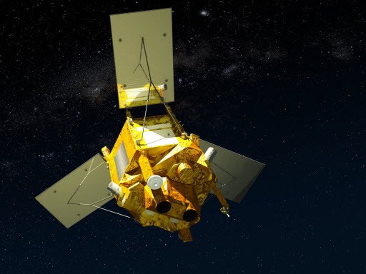
SPOT-7 is a high-resolution wide-swath imaging spacecraft built and operated by Airbus Defence and Space taking over the majority of Spot Image after the government support of the SPOT program was terminated. SPOT-6 – launched in 2012 – and SPOT-7 are identical spacecraft, based on the AstroSat-250 satellite bus and use the NAOMI (New AstroSat Optical Modular Instrument) payload to acquire optical imagery to ensure the continuity of SPOT data, building on experience gained through previous missions, particularly SPOT-5 that launched in 2002.
SPOT satellite imagery is marketed to commercial customers for a variety of purposes and data is also combined with radar imagery acquired by other satellites to generate high-level data products. The imagery covers wide ground swaths at a very high resolution and the spacecraft and orbit design allows for rapid revisit times as low as one day. Data is provided with low latency and is available to customers shortly after acquisition and the satellite provides just-in-time tasking capability.
The SPOT-7 spacecraft is built for a ten-year mission featuring two NAOMI cameras to cover a 60-Kilometer ground swath, 120km using single-pass mosaic imaging. Overall, the satellite can achieve a resolution of two meters in panchromatic and eight meters in multispectral mode covering the visible and near-infrared spectral bands.
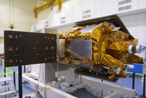
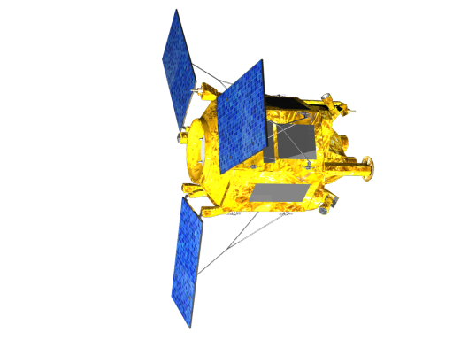
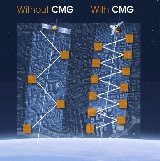
SPOT-7, based on AstroSat-250, measures 1.55 by 1.75 by 2.70 meters in size with a liftoff mass of 720 Kilograms. The Astrosat-250 platform uses a modular approach and provides a one-fault tolerant architecture across all subsystems. One of the most critical features of the satellite platform is the use of Control Moment Gyros that allow the satellite to make rapid attitude maneuvers for quick re-targeting
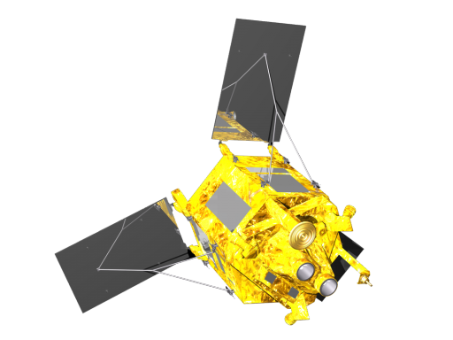
The AstroSat-250 bus is hexagonal in shape using composite panels and interior panels to provide mounting surfaces for the various satellite systems. The spacecraft is equipped with three deployable solar panels that are fixed in position and feature triple-junction Gallium-Arsenide solar cells. Overall, the solar panels provide a nominal power of 1,200 Watts using a shunt regulation system.
Optionally, a Maximum Power Point Tracker can be used to increase power output for payloads with higher power demand. Electrical power delivered by the arrays is passed to the Power Control and Distribution Unit that provides power regulation and distribution functions, conditioning an unregulated 28-Volt power bus and controlling the state of charge of Li-Ion batteries used for power storage.
Spacecraft Propulsion is accomplished using a Hydrazine monopropellant system. The PM22 system is used for rapid rate dampening in acquisition mode, in Earth-pointed safe mode and for regular orbit adjustment and maintenance maneuvers to keep the spacecraft orbiting close to its reference orbit. A series of thrusters are installed on two thruster pods that are supplied from a 104-liter propellant tank that operates in blow-down mode.
The 1N thrusters thrusters can tolerate supply pressures of 5.5 to 23 bars to generate a thrust of 0.36 to 1.45 Newtons. The corresponding specific impulses are 205 seconds at the lowest supply pressure and 221 seconds at the highest pressure. Each thruster assembly weighs about 0.23 Kilograms and can be operated in steady-state mode and pulse mode for attitude control.
Attitude control is provided by four reaction wheels and three magnetic torquers are used for coarse control and for momentum dumps of the reaction wheels. Three-axis attitude and orbit measurement is accomplished through a Star Tracker Assembly with three optical heads and a GPS unit. The star tracker delivers pointing knowledge of up to 30 µrad while the attitude control system provides a pointing accuracy of 500 µrad. An inertial measurement unit is used to improve three-axis rate measurements and serves as backup to the star trackers. The dual-frequency GPS receiver can be used for orbit determination with an accuracy of 3 meters. In spacecraft safe mode, attitude determination is provided by a Magnetometer and Coarse Sun Sensor that are used to keep the satellite in a safe Earth- or Sun-pointed attitude.
Payload data is downlinked via a two-channel cold redundant X-Band system that achieves a data rate of up to 300Mbit/s using QPSK modulation. The communication system uses a single isoflux antenna. Telemetry downlink and command uplink is accomplished using an S-Band system with omni-directional coverage.
Command & data handling, spacecraft control and communication is provided by a control system built around the SCOC3 Spacecraft Controller On-a-Chip that uses a LEON-3 microprocessor.
The redundant onboard computer provides processing, reconfiguration and timing functions, data input/output and customization capabilities. A Remote Interface Unit allows the spacecraft computer to be reconfigured in flight. Two 1553 data buses are used to handle spacecraft platform data and data acquired by the payload. The flight software used by the spacecraft is based on the RTEMS operating system with customizable software elements tailored for specific mission purposes. The flight computer uses an autonomous Failure Detection, Isolation and Recovery system.
Data delivered by the satellite payload is stored by a Compression Recording and Ciphering unit, CoReCi. This system uses flash-based technology and a modular approach to provide an incremental data storage capacity up to 10Tbit. CoReCi supports input data rates up to 1.4 Gbit/s. The system uses embedded Wavelet Image Compression, data ciphering using Advanced Encryption Standard, and data formatting according to ESA’s packet-telemetry standard. The system weighs 14 Kilograms and has a peak power consumption of 75 Watts.
The main payload of the SPOT7 spacecraft consists of two NAOMI optical imagers. The New AstroSat Optical Modular Instrument has extensive flight heritage having flown on the KazEOSat-1, SPOT-6, SSOT and VNREDSat-1A satellites. The instrument weighs 150 Kilograms and has a peak power demand of 180 Watts.
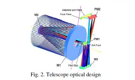
The instrument is a high-resolution pushbroom-type imager that was developed by EADS Astrium and SAS. NAOMI is comprised of an optical bench consisting of SiC to provide extremely high thermal stability, a focal plane assembly with Time Delay Integration Detector, back-end electronics for data processing and interfaces for data and command exchange with the spacecraft computer.
The telescope uses a Korsch combination with three aspheric mirrors and two folding mirrors using an aperture diameter of 20 centimeters. This design was chosen because of its simplicity and compact size – fitting within the small spacecraft platform. An entrance baffle is used for stray light rejection. Light entering the detector is passed from the primary mirror M1 onto the M2 mirror before passing Folding Mirror 1 to the M3 mirror that reflects the light through the Exit Pupil to Folding Mirror 2 that passes the light onto the detector.
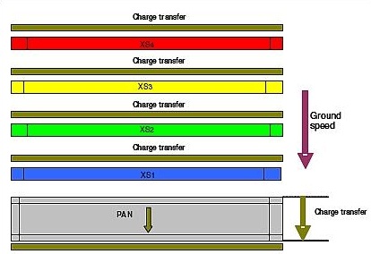
The Time Delay Integration detector uses a silicon CCD detector assembly with 7000 pixels for the panchromatic channel and four lines of 1750 pixels for the multispectral bands. All detectors are equipped with strip filters and front end electronics. The front end electronics provide the detectors with biasing and clocking signals as well as pre-amplification of the signals before transmitting them to the video electronics.
The back-end electronics provide power supplies for the operation of the front-end and provide data processing via modular video chains that operate at frequencies of up to 15Msamples/sec. The signals from the front end is digitally converted in the back end using a 12-bit conversion scheme and the data is then transferred for real-time processing and storage in the mass memory.
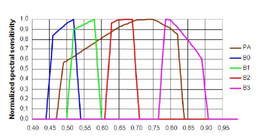
The instrument covers five bands – the panchromatic band of 450 to 750 nanometers and four multispectral bands including blue (450-520nm), green (530-600nm), red (620-690nm) and near infrared (760-890nm). The telescope covers a ground swath of 20 Kilometers and the spacecraft has a field of regard of +/-35 degrees (800km) as it is tilted around nadir for event monitoring. NAOMI on SPOT7 can deliver panchromatic images at a ground resolution of two meters at nadir while the multispectral imagery will reach resolutions of eight meters.
For imaging sessions, SPOT-7 can use its agile attitude control system to support a variety of observation modes. The spacecraft is capable of acquiring a multitude of scenes in a localized area – up to 11 scenes – each 60 by 60 Kilometers – can be collected within a 1,000-Kilometer long ground strip. Strip imaging is also possible and SPOT-7 can acquire multiple strips of a target area in a single pass with strip lengths of up to 600 Kilometers. Mosaic strip-imaging in which the satellite acquires multiple image strips of adjacent areas is also possible to cover an 300 by 330-Kilometer rectangular target area in a single pass. For regular imaging, SPOT-7 will use off-nadir angles up to 35 degrees which also allows the spacecraft to support quick-revisit times of one day.
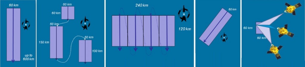
SPOT-7 can also collect stereo and tri-stereo images in one pass. Data is automatically geo-referenced using an automated system that operates at an accuracy of 10 to 20 meters after calibration.
SPOT-7 is planned to operate in a circular orbit at 695 Kilometers at an inclination of 98.2 degrees. The satellite will be phased into a constellation with the SPOT-5 and SPOT-6 satellites as well as the Pleiades 1A and 1B spacecraft to establish an Earth Observation Constellation with fast revisit times and quick response times to targets of opportunity.
SPOT-7 utilizes a simplified Ground Control Segment consisting of the CGS – the Control Ground Segment and the EGS – the Exploitation Ground Segment. The division of labor between these two components is very clear – the CGS is in charge of commanding the spacecraft, monitoring its health, performing periodic maintenance operations, planned orbital maneuvers and accepting the mission plan from the EGS. The EGS plans the targets that are to be imaged by the satellite and accepts all data downlinked by the spacecraft for processing, distribution to customers and archiving. SPOT-7 supports up to six mission plan updates per day allowing quick response times and just-in-time tasking with rapid delivery of data products after acquisition.
