
SARAL
SARAL or Satellite with ARgos and ALtiKa is an Earth Sensing Spacecraft that was developed by the Indian Space Research Organisation and the French Space Agency CNES. the satellite will also be operated by those two agencies.
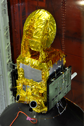
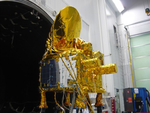
The satellite is part of the Global Monitoring for Environment and Security (GMES) initiative of the European Commission and the European Space Agency. It will fill a gap between Europe’s Envisat Program and Sentinel 3 mission, being similar to the NASA/NOAA/EUMETSAT Jason-2 mission. SARAL features four payloads, the AltiKa altimeter, DORIS (Doppler Orbitography and Radiopositioning Integrated by Satellite), a Laser Reflector Array and the ARGOS-3 system (Advanced Research and Global Observation Satellite).
SARAL will support environmental monitoring, oceanography and altimetry. SARAL will observe Ocean mesa-scale variability which is a high-energy process “with wave lengths within a 50km to 500km range, and with periods of a few days to one year,” a CNES document said. Measuring meso-scale dynamics is essential for understanding ocean dynamics, circulation and climatic effects. SARAL will also measure the main continental water level and sea level variations. It will also observe the polar oceans, study wave fields and sea ice, and examine marine biogeochemistry.
AltiKa is a Ka-Band altimeter that will provide data with very high spatial and vertical resolution to enable better observations of ice, coastal areas, continental water bodies and wave height. Similar systems are also used on Envisat and Jason-2 to ensure data continuity into the future. AltiKa is the first altimeter to operate at such high frequencies which holds two advantages. Previous altimeters rely on radar systems which a susceptible to atmospheric properties that can influence measurements by effecting the speed of radar signals so that satellites needed to carry additional equipment to correct measurements. The second advantage is a much higher accuracy.
AltiKa will provide ocean surface topography measurements with an accuracy of 8 millimeters at a spatial resolution of 2 Kilometers. AltiKa can also function as radiometer to provide atmospheric water content.
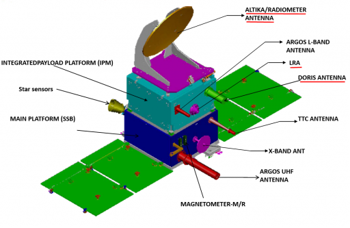
DORIS – Doppler Orbitography and Radiopositioning Integrated by Satellite – is a French system used for precise Satellite Orbit Determination and Positioning. The system features ground beacons and antennas on orbiting spacecraft that receive signals coming from the ground and make use of the frequency shift of the signal caused by the satellite’s movement. The Doppler Effect is used to precisely determine the satellite’s orbit along with other positional data. A total of 50 beacons are installed all over the world to allow continuous orbital tracking. The ground system infrastructure of the system is fairly simple as it only requires beacon transmitters that do not need to receive any data as the DORIS payload on the satellite is responsible for orbit determination and data storage/relay. DORIS enables orbit determination with an accuracy of two centimeters which is required to Earth/Ocean topography measurements.
The Laser Retroreflector Array instrument is used for calibration of other Precise Orbit Determination instruments by shooting a laser from the ground with its beam being reflected by the LRA mirrors.
ARGOS-3 is part of the ARGOS System which features a worldwide network of transmitters and ground stations to acquire, relay, downlink and process environmental data in real time or near real time. ARGO transmitters can be installed on mobile platforms such as sea vessels or fixed platforms, buoys and maritime animals like sea turtles.
The project has been established in 1978 in an agreement between CNES, NOAA and NASA and since then, the number of transmitters has been steadily increasing. The ground transmitters can be small sensors just measuring a few environmental properties, but many remote weather stations that acquire large data sets are also part of the system.
The ground platforms record environmental data and periodically transmit it via UHF frequency which is picked up by orbiting spacecraft. The data sets are then relayed via X-Band to one of 40 ground stations, usually in real time, so that the data can be transmitted to an ARGOS center in the US or France for processing and distribution.
The SARAL Satellite Bus was provided by the Indian Space Research Organisation. The vehicle is based on the IMS-2 Small Satellite Bus weighing about 409 Kilograms at launch. The satellite bus is 0.98 by 0.98 y 2.6 meters in size. The satellite features two 1.2 by 1.4-meter solar arrays that deploy once in orbit for a total power generation of 570 watts. Telemetry downlink is accomplished via S-Band that provides a 64kbit/s link for telemetry downlink and 4kbit/s uplink speed. The satellite has an expected lifetime of 7 years.
