Fengyun-4 Weather Satellite
Fengyun 4 (FY-4) represents China’s second generation of Geostationary Meteorological Satellites intended to build the high-altitude component of the country’s space-based weather now- and forecasting system through the 2030s. FY-4 introduces significant improvements over the current system which employs spin-stabilized satellites that can only achieve a fraction of the observation efficiency possible with three-axis stabilized satellites.
Fengyun (Chinese for ‘Winds and Clouds’) is China’s Meteorological Satellite Program, consisting of at least one operational satellite in Geostationary Orbit and several satellites in polar orbits, creating a satellite constellation to monitor the Chinese and surrounding territory and deliver timely data relevant for weather forecasting and nowcasting. The program saw its first launch back in 1988 when the Fengyun 1A satellite was launched into a Sun-Synchronous Orbit – Fengyun 1B followed in 1990.
Operating weather satellites in Geostationary Orbit to generate data with high time resolution in combination with satellites in sun-synchronous orbit that achieve a high spatial resolution has become common in many of the worlds meteorological satellite systems.
The development of the Fengyun 2 satellites as the Geostationary component of the constellation started in the 1980s and the first satellite was ready for launch in 1994, however, when being loaded with propellants for flight, the satellite exploded, killing one technician, injuring 20 more and setting back the entire program that went through a re-design of the satellite’s propulsion system.
As a result, the first Fengyun 2 satellite launched three years later than originally planned.
A total of seven FY-2 satellites were launched as part of the program, entering positions at 86.5 and 105° East in Geostationary Orbit. Of the FY-1 polar orbiting series, four satellites have been launched with FY-1C making the news in 2007 when it was destroyed as part of a anti-satellite test conducted by the Chinese, creating a large debris cloud in orbit.
The FY-1 generation of satellites was succeeded by the FY-3 satellites, the first of which launched in 2008 and was followed by two more in 2010 and 2013 to keep up a steady flow of meteorological data from a Low Earth Orbit, carrying payloads for atmospheric sounding, spectral imaging, radiation monitors, and specialized instruments such as GNSS occultation and ozone sensors.
Fengyun-4 is operated by the China Meteorological Administration with satellite development and manufacture completed by the China Academy of Space Technology. Two versions of the FY-4 satellites will be built, one outfitted with optical sensors, the other carrying a microwave payload.
Compared to FY-2, the next generation of Geostationary Meteorological Satellites has been considerably improved in terms of the quality and volume of data delivered, the network transmission bandwidth, data product generation and distribution – enabling an easier integration into forecasting and other applications. FY-4 offers an enhanced scanning capability to be able to monitor small-scale weather phenomena while the microwave version addresses the need for three-dimensional sensing of the atmosphere from geostationary altitudes. As a new capability, FY-4 carries a solar payload to establish a space weather monitoring and warning capability.
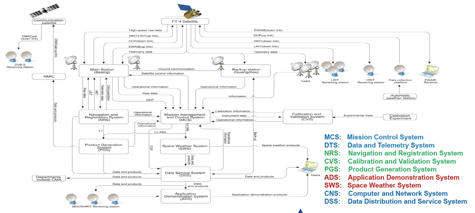
Services provided by the FY-4 system include imaging, sounding, lightning mapping, and space environment monitoring plus auxiliary services – High- and Low-Rate Information Transmission, and support of Data Collection Platforms.
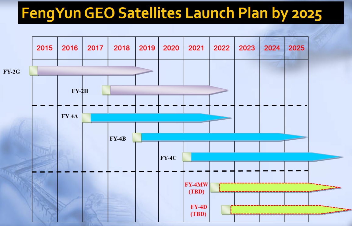
The first FY-4 satellite launches in late 2016 and will be followed by FY-4B in 2018, both have a desired mission duration of five to seven years at the end of which they will be replaced. A total of seven FY-4 satellites are planned to be launched to remain in service through 2037 when a successor program will be inaugurated.
The first three satellites to be launched under FY-4 are projected to be carrying optical payloads with the microwave component of the constellation expected to be introduced no earlier than 2022.
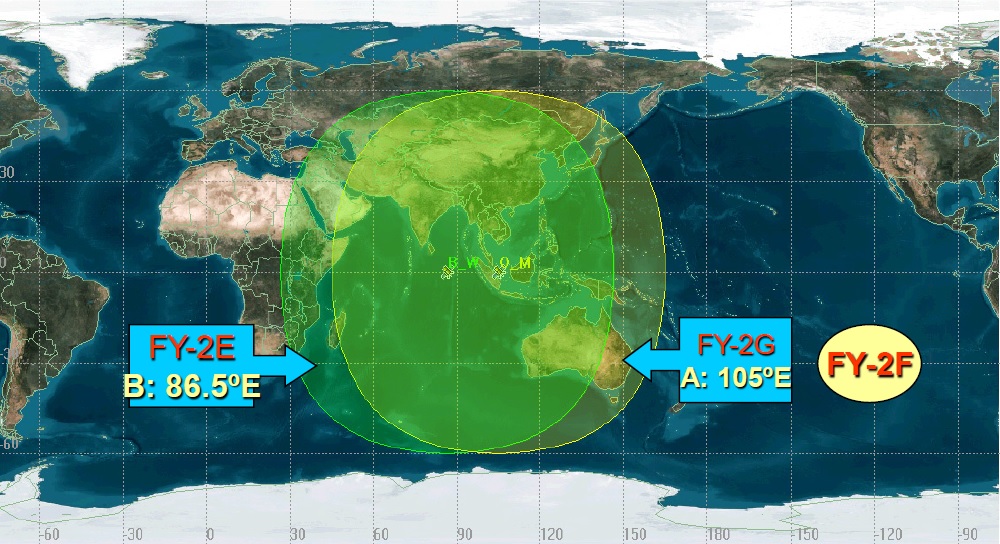
The optical component of the FY-4 constellation will comprise a pair of satellites to cover a large region from the Middle East all the way to the Pacific Ocean. FY-4 Microwave is envisioned to only cover China and some peripheral areas.
FY-4A, launching in 2016, is considered a pre-operational pathfinder mission with an expected satellite live of five years while operational satellites, starting with FY-4B, will be expected to operate for seven years or more.
The FY-4 Optical System has five distinct mission objectives: a) obtaining multi-spectral images of Earth and clouds at high temporal resolution, b) measuring humidity profiles in the atmosphere, c) measuring relevant solar and space weather parameters, d) collecting relevant environmental monitoring parameters, and d) broadcasting images, data products and warnings of adverse weather conditions.

The FY-4 Optical Satellites carry four instruments – an Advanced Geosynchronous Radiation Imager as a multi-band imaging payload, a Geostationary Interferometric Infrared Sounder, a Lightning Mapping Imager and a Space Environmental Package. FY-2 only carried a visible and infrared imaging instrument and a space environment sensor, providing rudimentary capabilities when compared to the FY-4 system.
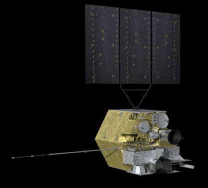
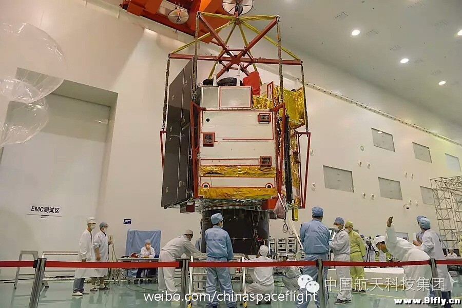
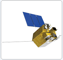
The Fengyun-4 satellites are based on the SAST-5000 satellite platform developed by the Shanghai Academy of Space Technology for Earth Observation Satellites operated from different orbital regimes. FY-4 has a launch mass of 5,300 Kilograms and hosts a single three-panel solar array delivering more than 3,200 Watts of power to the satellite for distribution to the various subsystems.
The SAST-5000 platform hosts an attitude determination system relying on star trackers, inertial measurement systems and Earth/Sun sensors with reaction wheels acting as the primary attitude actuator, achieving a high pointing accuracy of 3arcsec at low jitter to keep the satellite in a precise Earth-pointed attitude. Internal communications on the satellite use the 1553B communications standard and high-speed SpaceWire which supports the data rates required by the instruments and allows for easy integration. Downlink of raw instrument data is completed in real time via a high-speed X-Band terminal operating at 7500MHz.
Advanced Geosynchronous Radiation Imager (AGRI)
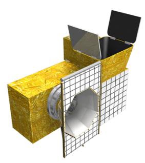
The Advanced Geosynchronous Radiation Imager (AGRI) is the primary instrument of the FY-4 Optical Series. It is a multispectral imager with a two-axis scanning geometry, vastly expanding previous capabilities by adding spectral channels, improving spectral and spatial resolution of imagery, and employing a much faster data acquisition scheme.
AGRI uses heritage from the Advanced Baseline Imager of the GOES-R-series satellites debuted in 2016 and operated by NASA/NOAA. Both instruments have been developed by Harris Corporation in the U.S. and share a number of common elements, though their capabilities have been tailored to each mission’s specific objectives.
AGRI replaces the S-VIISR instrument of the FY-2 series which covered five spectral channels and collected one Full Disk Image of Earth every 30 minutes at a resolution of 1.25 to 5 Kilometers. The next-generation instrument adds significant capabilities, covering 14 spectral channels and delivering full disk images every 15 minutes at a significantly improved resolution of 0.5 to 4 Kilometers. In terms of data volume, AGRI delivery approximately 160 times the information S-VIISR generated.
AGRI employs an off-axis telescope with two scan mirrors which sweep out an East-West image swath and step in the North-South direction after each successive sweep to assemble global or regional images.
AGRI covers three bands in the visible and near-infrared wavelength from 450 to 900 nanometers while the remaining eleven bands are sensitive for Shortwave, Midwave and Thermal Infrared wavelengths stretching from 1.36 to 13.8 micrometers. The resolution is band dependent and ranges from 0.5 to 1km for the visible/NIR and 2.0km for short- and mid-wave IR to 4.0km for the water vapor and thermal infrared channels.
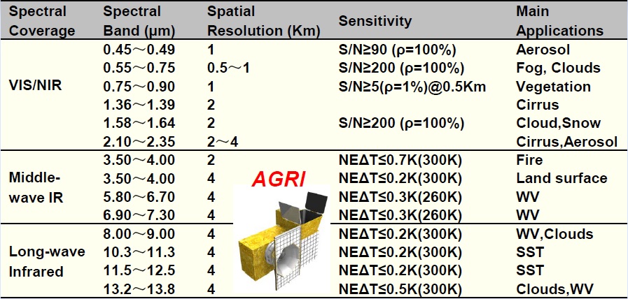
The VIS/NIR infrared channels are primarily used for aerosol assessments, cloud and fog imaging and vegetation assessments while the SWIR bands deliver valuable data for cloud differentiation. MWIR data is employed for hot-spot detection (fires) and land surface monitoring, two channels are optimized for atmospheric water vapor retrievals and the four thermal infrared channels enable water vapor and cloud measurements as well as sea surface temperature detection.
AGRI facilitates separate detector planes fed by a series of beam splitters and dichroic elements with different thermal requirements for the VIS/NIR and MWIR/TIR detectors. A total of 216 detector elements are employed by the instrument with active cooling to reduce dark currents for IR detection.
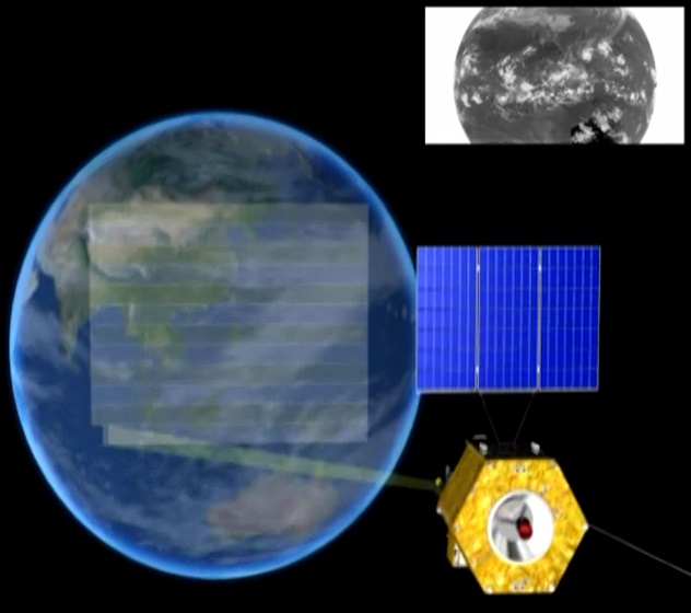
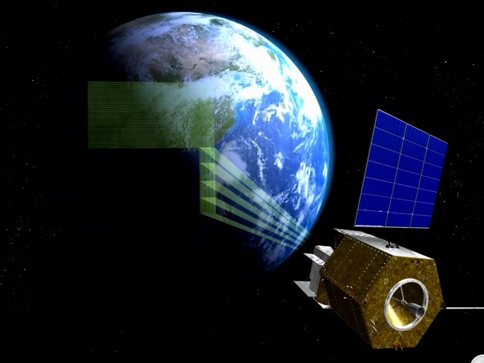
The AGRI instrument support two imaging sectors, a Full Disk and a Regional Coverage area. Full Disk imagery is acquired by completing E-W scans across the entire visible globe with an image acquisition time of 15 minutes; Regional imagery can be collected of areas of interest where weather systems are developing to gain a higher temporal resolution with imagery available every 2.5 minutes.
As the primary instrument of the mission, AGRI (together with the lightning mapper) is responsible for 23 of 28 data products generated through ground processing.
Geosynchronous Interferometric Infrared Sounder (GIIRS)
The GIIRS instrument is a new addition to the FY-4 satellites, enabling vertical atmospheric sounding from Geostationary Orbit to gain insight into the internal constitution of the atmosphere and relevant parameters on precipitation, temperature, humidity and disturbances. GIIRS was developed by the National Space Science Center of CAS.
It is the first high-resolution sounder to be deployed to Geostationary Orbit.
GIIRS is a Mid-Wave/Thermal Infrared Sounder with large detector arrays for simultaneous sounding of a larger area plus Visible coverage support for cloud detection. The instrument operates by stepping dual scanning mirrors to subsequent scan positions with a specific dwell time over each location for data acquisition. On FY-4A, GIIRs covers 538 Long-Wave Infrared Channels and 375 Mid-Wave Channels, to be expanded to 1,188 detectors on operational missions of FY-4B and forward.
The instrument is sensitive in three bands – 4.44 to 6.06 µm and 8.85-14.3 µm in the infrared wavelength range and 550 to 750 nanometers in the supporting visible channel. It achieves a resolution of 8 Kilometers (FY-4A 16km) in the infrared and 2km in the visible band.
The GIIRS detectors employ a deep data quantization of 13 bits and active coolers keep the 32×4 focal plane at a constantly low temperature for dark current reduction.
Two observation modes are supported by GIIRS – one mode is designed to collect data across the entire Chinese territory, covering a 4500 x 4500-Kilometer area on the ground and generating one data set every 55 minutes. The other operational mode delivers data across a 1000 x 1000-Kilometer regional frame every 30 minutes during standard instrument operation.
Data delivered by GIIRS is used to for atmospheric temperature profiles, cloud top height and temperature, sea surface temperature, specific humidity profiles, integrated water vapor measurements, cloud cover maps, land surface temperature, horizontal winds, total column ozone, and cloud type discrimination.
Lightning Mapping Imager (LMI)
The LMI instrument, also known as GLI (Geostationary Lightning Imager), is China’s first dedicated lightning detection sensor hosted by a satellite. Its primary objective is to measure lightning activity in real time to be employed by meteorologists to forecast severe weather, storm tracks and convection precipitation. A long-term data record will also permit scientific studies including an examination of Earth’s electric field.
LMI data will also be used to improve mesoscale forecast models and retrievals of convective properties. The instrument is very rapid in acquiring lightning data, allowing for near-real time assessments of lightning activity while data records can provide insights into interannual variability of storms and lightning climatology.
LMI is a staring instrument optimized to detect the infrared signature of lighting, both during the day and night and for cloud-to-cloud as well as cloud-to-ground lightning. The instrument comprises a pair of staring imagers to reach the required spatial coverage over the Chinese territory, watching over a ground area of 9,000 Kilometers (diagonal field of view) with a pair of 400 by 300-pixel sensors using conventional Charge Coupled Device detectors.

LMI employs optical filters to narrowly select the 777.4 +/-0.5-nanometer band – tuned to the oxygen triplet line very prominent in the lightning spectrum. The instrument achieves a resolution of 7.8 Kilometers at the sub-satellite point and 14 Kilometers on the edge of the field of view, providing sufficient location accuracy for the detection of lightning and storm motion.
Similar to the GLM instrument on the American GOES-R, LMI operates at a frame rate of 500 images per second, but does not transmit images and instead processes them in real time to work as a lightning event detector.
Raw frames are processed by the a real time processing system that is capable of identifying lightning signals whenever a selected signal difference threshold between frames is detected. The system can correctly identify more than 90% of lightning events with false alarms kept below 10% of total measured events.

The processing system compares the value of each detector pixel to a stored background that represents an average of the recent history of that pixel. If the read-out from a pixel exceeds a selectable threshold, an event is triggered. The background is a moving average with an adjustable time constant that determines over how many recent images the average is built.
When an event is triggered, the processing system creates a data structure that includes the time, position of the pixel, its intensity with respect to the background, and the value of the background itself. The event records transmitted by the spacecraft are put through a series of ground processing steps to remove non-lightning events caused by radiation hits and sun glints.
Space Environment Monitoring Instrument Package
The Fengyun-4 Space Environment Monitoring Instrument Package (SEMIP) comprises two principal components – a Space Environment Monitor and a Fields Package to measure high-energy particles in near-Earth space as well as the magnetic field which is important since it drives charged particle dynamics in the magnetosphere.
The Space Environmental Monitor hosts a pair of detectors to measure the energy of incoming protons and electrons to deliver a complete picture of the energetic particles that are either trapped in Earth’s magnetosphere or arriving directly from the sun or cosmic rays. A High-Energy Proton Detector hosts eight channels in the energy range of 1 to 165 Mega-Electronvolt with a conical field of view of 60 degrees; and the High-Energy Electron Detector covers nine channels for energies between 0.4 and 4 MeV with a 25-degree field of view directed toward the zenith.
The Fields Package comprises a Fluxgate Magnetometer, Radiation Dosimeter and Surface Charging Sensors.
The Magnetometer resides on a deployable boom to place the sensitive sensor as far away as possible from the spacecraft’s own magnetic field created by the onboard systems. It has a dynamic range of +/-600 Nano Tesla and delivers data at a resolution of 0.01nT, sampling at a cadence of 0.06 seconds.
Dose Rate and Electrostatic Charge measurements in Geostationary Orbit are important for an assessment of potentially hazardous conditions for the satellite arising from the space environment.
Solar X-EUV imaging telescope (SXEUV)
Beginning with Fengyun-4B, the satellites will host a dedicated solar payload known as the Solar X-EUV imaging telescope which captures X-rays at energies of 1 to 10keV and extreme ultraviolet radiation from 10 to 130 nanometers which includes important transition regions of iron, helium and hydrogen serving as excellent tracers of solar activity.
Diagnostics of the thermodynamic state of the solar atmosphere has become an important aspect of forecasting, allowing for predictions of solar phenomena capable of impacting space weather.
Space weather forecasting has become important for the protection of human-engineered assets such as satellites, aircraft, radio communications system and power grids on the ground.
Auxiliary Services

FY-4 supports the data collection system featuring a UHF antenna to receive messages from DCS Platforms deployed in remote locations on Earth. DCPs can be deployed virtually at any location on the globe to provide in-situ measurements of meteorological data that is then uplinked to satellites and transmitted to ground stations for collection, processing and distribution. The DCPs operate in the UHF band at 401/402 MHz. These platforms include remote weather stations, buoys at sea to measure sea state and alert in the event of tsunamis as well as other measurement stations that are deployed in remote locations.
The FY-4 satellite also supports High and Low-Data Rate Direct Broadcast Capabilities to deliver instrument data directly to users within the satellite’s footprint. Low Data Rate Information is transmitted at 1697MHz and delivered at a data rate of 150kbps while the HRIT direct broadcast is broken down in three channels – an 8Mbps channel for AGRI and LMI data at full resolution (1681MHz), 3Mbps for resampled AGRI data (1679MHz), and 1Mbps for GIIRS data.