
Cassiope Satellite Overview
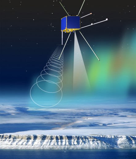
Cassiope, the CAscade, SmallSat and IOnospheric Polar Explorer is a project managed by the Canadian Space Agency. The small satellite is 1.80 by 1.40 meters in size with a liftoff mass of about 481 Kilograms hosting two main payloads – e-POP (enhanced Polar Outflow Probe) and the Cascade commercial communications system. The satellite bus, called the Multi-Mission Small Satellite Bus or MAC-200, will be tested for use on future missions.
The spacecraft consists of aluminum honeycomb panels that are held together by aluminum brackets and stringers creating a hexagonal spacecraft structure.
The satellite is equipped with body-mounted solar panels that feed power to a Power Control Unit that distributes power to satellite and payload systems and controls the state of charge of two Lithium Ion Batteries. The Electrical System of the satellite provides a 28-Volt power bus.
The core of the satellite is a redundant Command and Data Handling System featuring a PowerPC that controls all satellite and payload functions. Satellite thermal control is provided passively by Multilayer Insulation as well as several heaters that are actuated based on thermal sensor data.
Cassiope is equipped with a zero-momentum Attitude Determination and Control Subsystem that uses two Micro Advanced Stellar Compasses, six Sun Sensors, two star trackers and two magnetometers for attitude determination while attitude actuation is provided by four reaction wheels and three torque rods.
The satellite communicates with ground stations via S-Band while the Cascade Payload features a Ka-Band System. Via two redundant S-Band transmitters, each featuring two antennas, the satellite achieves data rates of 4Mbit/s for downlink and 125Kbit/s for uplink.
The e-POP Payload is comprised of a suite of eight instruments to study atmospheric and plasma flows and related wave-particle interaction and radio wave propagation in the upper ionosphere. E-POP will provide valuable data on near-Earth space weather and improve future forecasting of space weather events. The project is led by the University of Calgary. Specific objectives of e-POP include the quantification of micro-scale plasma characteristics of plasma outflow and other plasma processes in the ionosphere.
E-POP will make in-situ measurements of charged particle distribution, waves and fields in high resolution both temporal and spatial, supplemented by imaging and tomographic measurements. The instrument is supported by ground-based observations that provide additional data.
E-POP Instruments
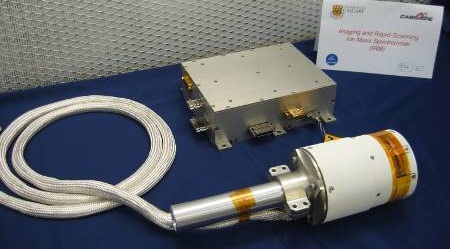
The Imaging and Rapid-Scanning Ion Mass Spectrometer, IRM, will study the mass composition and three-dimensional velocity distributions of ions in the ionosphere at an energy range of 0.1 to 100 electron volts. The IRM sensor is cylindrical in shape and is installed on an 8-centimeter boom to facilitate the 360-degree field of view of the instrument perpendicular to the deployment axis and the 120-degree FOV along the deployment axis. The main electronics box of the instrument resides inside the satellite body.
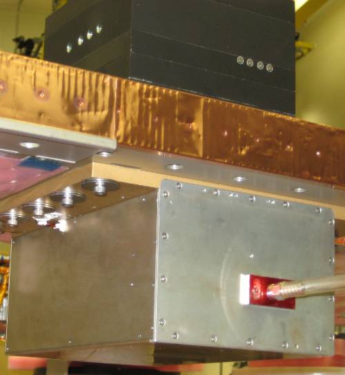
The Neutral Mass Spectrometer, NMS, is operated during perigee passes in a zone of high atmospheric density to make in-situ measurements of neutral particles. The instrument consists of an open ion source using electron impacts, and a microchannel plate (MCP) detector.
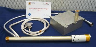
The Suprathermal Electron Imager, SEI, will look at two-dimensional energy and angular distributions of electrons in the 1 to 200 eV range. SEI focuses on photoelectrons with energies of 1 to 50eV as they play an important role in particle outflow from the polar regions. The sensor is installed on an 80-centimeter boom to place it at some distance to the satellite that would shield the instrument from the particles. The instrument uses a 256 by 256 pixel Charge Coupled Device detector operating at an imaging rate of 100 read-outs per second.
NMS Instrument
The Fast Auroral Imager, FAI, features two imagers – one near-infrared imager and a narrow-band visible imager operating at 630 nanometers. The 630nm imager uses a 128 by 128 pixel array hosted on a back-illuminated high quantum efficiency and low noise CCD with a resolution of 0.4km at perigee and 4.7km at apogee with exposure times of 0.5 seconds every 30 seconds. The NIR camera uses a 256 x 256-pixel detector that operates at exposure times of 0.1 second every second creating imagery at a resolution of 0.4km at perigee and 2.6km at apogee. Aurora imagery provided by FAI will help study mechanisms of auroral excitation, black aurora phenomena in relation to streaming electrons and ions, large scale convection and the connection between aurora and ion energization.
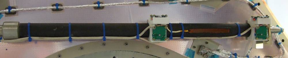
The Magnetic Field Instrument, MGF, consists of a fluxgate vector magnetometer with two sensors mounted on 80cm booms to measure small electric currents flowing to and from the auroral ionosphere to determine the spatial distributions of the field aligned currents with respect to other measurements made by the e-POP instruments.
The Radio Receiver Instrument, RRI, picks up radio waves in the Ultra High and High Frequency range. The instrument consists of a four-channel radio receiver that is used to detect the electric fields of spontaneous waves and waves created by ground transmitters. The instrument will provide data on the structure of the ionosphere, radio emissions by auroral processes, plasma physics of the ionosphere and diffraction and refraction of radiowaves.
The Coherent Electromagnetic Radiation instrument, CER, facilitates a a three-frequency beacon and its antenna is mounted on a 69-centimeter boom that emits signals at 150, 400, and 1066 MHz. These signals are picked up by ground stations to produce two-dimensional ionospheric density maps in order to study the total electron density of the ionosphere.
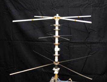
The GPS Attitude and Positioning Experiment, GAP, measures the velocity and attitude of the spacecraft along with Total Electron Content in the ionosphere by making GPS occultation measurements. The instrument consists of one suite of three single-frequency GPS receivers and four patch antennas, and a suite with a dual frequency GPS receiver.
The first suite is used to provide time-interference data to calculate the spacecraft attitude, spacecraft position and velocity. To create this data set, the four GPS antennas are mounted on opposite sides of the spacecraft in order to measure the arrival times of the various GPS signals at each antenna against a very stable time base which provides the position and velocity of the satellite. The dual-freq receiver detects the electron density profile of the ionosphere by making occultation measurements.
Cascade
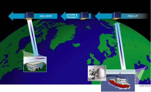
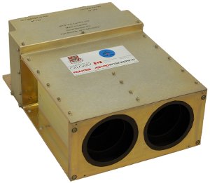
The Cascade Payload of the Cassiope satellite will demonstrate a new communications system serving as a proof of concept for a broadband store and forward system. A possible future system will provide a large scale data transfer system to provide data transfer to remote commercial, civil and military users around the world. The individual satellite serves as a “Courier in the Sky” picking up a data packet from any point on Earth the satellite overflies and delivering it to a recipient that can be located anywhere under the satellite’s track.
The Payload consists of a high-speed Ka-Band Payload for data packet reception and downlink and a mass data storage of 1TB+. Cascade will receive data packets of 50 to 500GB from ground stations and downlink it to a different user ground station as the satellite passes overhead with data rates of up to 1.2GB/s.
