
TeLEOS-1 Satellite
TeLEOS-1 is Singapore’s first commercial Near Equatorial Orbit (NEqO) Earth Observation Satellite, built by ST Electronics and operated by Agil Space to deliver one-meter resolution imagery of Earth at an exceptionally high re-visit rate of 12 to 16 hours to bring to users a unique capability of accessing temporal imagery of time-sensitive events.
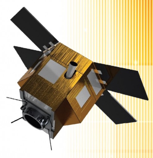
The spacecraft has a liftoff mass of 400 Kilograms and measures 1.9 by 2.0 by 1.6 meters in size, utilizing a hexagonal satellite platform structure which is common in small-satellite remote sensing missions. The external panels of the satellite are used facilitate the various satellite subsystem components while a central tube facilitates the optical telescope. Four solar panels are hinged on the aft and of the spacecraft and stowed against the side panels during launch. The arrays are fixed in place. The external panels also facilitate radiators for thermal control.
The TeLEOS-1 satellite uses star trackers as primary attitude determination system assisted by Inertial Measurement Equipment and Sun Sensors. Attitude actuation uses reaction wheels and the control system is capable of agile satellite pointing with high accuracy and slew rates of 2.5 degrees per second.
Payload data is stored in a 64-Gbit solid state recorder and downlinked to ground stations using an X-Band terminal that achieves data rates of 150 Mbps. S-Band is used for telemetry downlink and command uplink.
The payload of TeLEOS-1 is an electro-optical imaging instrument. The instrument covers a 12 by 12-Kilometer swath at nadir and achieves a ground resolution of one meter in the panchromatic band. The image detector has a 10-bit dynamic range.
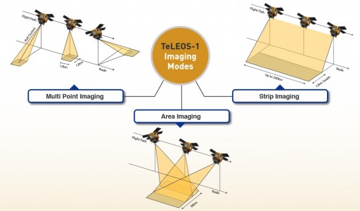
TeLEOS-1 can support off-nadir imaging up to 45 degrees off either side of spacecraft nadir. Supported imaging modes include strip imaging in which a strip of 12-Kilometer width and up to 200 Kilometers in length is imaged by the satellite either directly nadir or anywhere in the operational roll range. Multi-point imaging utilizes the satellite’s agile pointing to acquire images of multiple 12 by 12-Kilometer frames along the ground track. Finally, area imaging uses the satellites attitude control system to orient the spacecraft so that one pass over a given target is sufficient for a 36-Kilometer wide area to be imaged.
The TeLEOS-1 satellite operates from a circular orbit of 550 Kilometers and an inclination of 15 degrees. In this orbit, the satellite can only acquire imagery of the equatorial areas as a complement to Sun Synchronous Satellites that achieve global coverage. The advantage of a low-inclination orbit is that a high revisit time can be achieved with up to six daylight imaging opportunities per location per day. On average, the satellite will be able to reach a revisit rate of 12 to 16 hours. Furthermore, this orbital setup also allows the satellite to make multiple ground station passes per day, enabling it to downlink a great volume of data.
The TeLEOS-1 mission uses multi-ground station support to increase the downlink data volume and AgilSpace has signed image distribution contracts with South Korea’s Satrec Initiative and Spot Asia, an Airbus Defence and Space subsidiary. Imagery will be offered on the commercial market for a variety of applications such as homeland security and border control, maritime situational awareness and disaster monitoring and management.
The satellite is built to support direct tasking, imaging and downlink to provide a large number of imaging opportunities and it supports imaging on short notice. TeLEOS-1 is expected to operate for at least five years.