
Identifying the classified NROL-52 Satellite

NROL-52 can be identified with a fairly high degree of certainty as belonging to the fourth generation of the classified Space Data System operated by the U.S. National Reconnaissance Office to relay data from U.S. intelligence-gathering assets in real time, including image reconnaissance data collected by the Keyhole satellites in elliptical polar orbits.
The Space Data System, in addition to relaying data to and from a variety of satellites, also supports the Air Force Satellite Control Network by connecting ground stations and also provides communications relay to Air Force aircraft on polar routes.
The NRO is an intelligence agency tasked with the design, construction and operation of all U.S. reconnaissance satellites as well as the distribution of satellite intelligence to other agencies including signals intelligence for the NSA, image reconnaissance to the NGA and measurement and signatures intelligence to the DIA. Established back in 1961, the NRO is shrouded in great secrecy and most of its active programs are highly classified with declassification only possible decades after the end of specific programs.

As an intelligence agency, the NRO makes great efforts to keep its activities secret, therefore the identity of any and all NRO satellites are classified. However, it is possible to identify the nature of satellites by analyzing their launch trajectory as available in navigational warnings to mariners and pilots, the type of launch vehicle to constrain an approximate satellite mass and the launch window to assess possible target orbits.
Typically, NRO satellites are tracked in their secret orbits within a few days by a worldwide network of satellite observers, revealing from where they operate which usually provides a good idea of a satellite’s purpose.
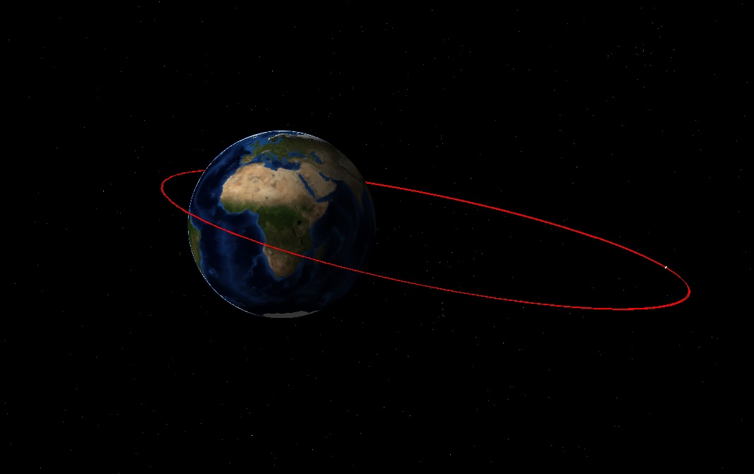
The case for NROL-52 appears straightforward since the mission is a close repeat of the 2016 NROL-61 mission that launched out of Cape Canaveral on an Atlas V 421 rocket and deployed the single payload into a Geostationary Transfer Orbit. That launch marked the first NRO use of the Atlas V 421 variant with a pair of Solid Rocket Boosters and an Extra-Extended Payload Fairing.
NROL-61 had already been suspected to belong to a new generation of the Satellite Data System based on the typical launch cadence for SDS and the apparent change to a more-powerful rocket from the Atlas V 401 used for the previous SDS missions suggested the new satellite generation was heavier. Tracking of the NROL-61 satellite confirmed it maneuvered into a Geostationary Orbit from where SDS is known to operate.
Similarities between NROL-61 and 52 are the type of launch vehicle, not used in any other NRO program, the launch site, and the expected ascent trajectory – though final confirmation of the satellite’s identity will come after launch once orbital parameters can rule out the possibility of a one-off mission.
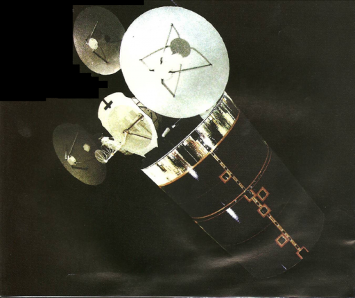
The Satellite Data System, also known by its code name Quasar, saw its first launch in 1976 using a Titan-3 rocket. The first generation satellites – at least seven of which were launched until 1987 – weighed in at under one metric ton and operated from a Molniya-type orbit with their apogee locked over the northern hemisphere to enable data relay from the polar regions.
In addition to satellite data relay, the SDS craft support communications to U.S. Air Force aircraft in the northern regions and connect the Air Force Satellite Control Network ground stations.
The second generation of Quasar satellites was inaugurated in 1989 – Three second generation satellites were launched on the Space Shuttle while the last one, lofted in 1996, used a Titan-4 rocket. It is believed that the second generation SDS carried an infrared early warning system for the detection of ballistic missile launches with the satellites weighing in at around three metric tons. Three of the SDS-2 satellites were delivered to Molniya-type orbits with a 39,700-Kilometer apogee while one entered a Geostationary Orbit.
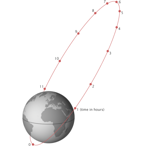
The third generation of SDS satellites incorporates a combination of satellites in highly elliptical Molniya orbits for coverage of the northern regions and spacecraft in Geostationary Orbit to deliver round-the-clock global coverage.
The replenishment of Molniya satellites apparently ended in 2007, likely marking the transition to a purely GEO-based system. Improvements in technology have allowed GEO satellites to service high-latitude regions, though polar coverage is still a challenge when only using satellites in GEO.
Eight third generation SDS satellites were launched between 1998 and 2014 with a launch cadence of around two to three years to keep the constellation at operational strength. The satellites used Atlas-IIAS, Atlas-V 401 and Delta IV M+(4,2) launch vehicles.
The use of the more-powerful Atlas V 421 indicates the next generation of SDS satellites, to which NROL-61 and 52 are believed to belong, has gained mass compared to their predecessors that used Atlas V vehicles without any boosters. Based on the injection orbit of NROL-61 and the known performance of Atlas V 421, it becomes clear that the SDS-4 generation may weigh up to around 5.1 metric tons per satellite.
Previous SDS launches utilized the Long Payload Fairing of the Atlas V rocket measuring 12 meters in length while the NROL-61 and 52 missions employed the 13.8-meter Extra-Extended Fairing, suggesting the next generation of SDS satellites requires more space inside the fairing, most likely for more or larger communications antennas.
A worldwide network of satellite trackers will attempt to spot the NROL-52 satellite after launch and track its climb into Geostationary Orbit and possible moves it will make to enter its operational spot above the Earth to provide further proof of the satellite’s identity.
