
Meteor-M #2
Meteor-M Satellite
The Meteor-M #2 satellite is the second in Russia’s fourth generation of meteorological satellites. The Meteor project goes back to 1961 when the Russian government initiated the development of a constellation of meteorological satellites carrying TV camera systems for monitoring of cloud cover, particularly for military purposes such as the operation of photo-reconnaissance spacecraft that carried a limited amount of film and relied on clear skies to acquire imagery of ground targets.
The Meteor satellite series began development which included the implementation of a gyro system for spacecraft stabilization, a revolutionary development as the space program was still in its early beginnings. In 1963, two testbed satellites were launched to demonstrate the three-axis stabilization system as well as new solar array technology and thermal protection for prolonged sun exposure. The first experimental Meteor satellite was launched in 1964 followed by nine more until 1969 while the 11th was lost in a launch failure.
The operational Meteor-1 generation was inaugurated in 1969 and saw 27 launches through 1977. The Meteor-1 satellites carried an optical instrument with a ground resolution of under three Kilometers, a TV infrared imager with a resolution of 15km and a radiation sensor.
Meteor-M #2
The Meteor-2 series was first launched in 1975 and featured a number of improvements such as the addition of a five-channel scanning radiometer and the use of three visible/infrared frame scanners. A total of 21 Meteor-2 spacecraft were launched until 1993. From 1974 to 1981 a series of six Meteor-Priroda satellites were launched using the Meteor-2 bus, but a different payload consisting of a four Multispectral Scanners, a Passive Microwave Radiometer, an infrared spectrometer and a radiation sensor. The scanners reached resolutions of up to 28 meters.
The Meteor-3 satellite series made its debut in 1985 seeing a total of 6 successful launches until 1994. Meteor-3 spacecraft were outfitted with two TV imaging systems covering a wide swath, an infrared radiometer with high ground resolution, a multichannel spectrometer, a radiation sensor, an ozone-mapping instrument and two international payloads – the Scanner for Radiation Budget of the French Space Agency and the German Microwave Tracking System.
A single Meteor-3M satellite was launched as a follow-on to the Meteor-3 series carrying a total of nine instruments that included an optical imager, infrared radiometer, microwave humidity sounder, a multispectral imager, a space-environment sensor suit, radiation monitoring equipment, aerosol and gas sensors and a spectrophotometer. The second satellite of the series, designated Meteor-3M #2 was planned to combine the meteorological payload with a high-resolution optical payload of the Resurs Earth Observation satellites, but the program was canceled in favor of Meteor-M. After the failure of Meteor-M3 in 2006, Russia had to purchase data products from other agencies for weather forecasting purposes.
Meteor-M represents the next generation of meteorological satellites that were planned to restore Russia’s capability of gathering meteorological data. The plan for the re-institution of the Russian meteorological called for at least three satellites in sun-synchronous orbit and three spacecraft in Geostationary Orbit to provide all data products needed for an operational weather forecasting capability, with real-time coverage and measurements of space weather.
The first Meteor-M satellite was launched in 2009 to demonstrate the satellite bus and instrument payload of the new Meteor-M series that makes use of state-or-the-art components to gather high-quality data products according to international meteorological standards.
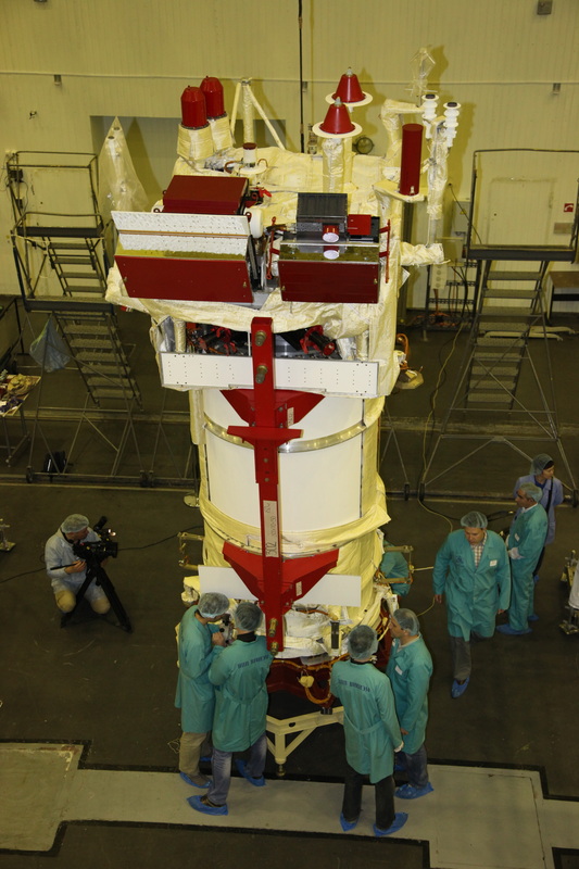
The Meteor-M satellites are built by VNIIEM, Moscow, each satellite weighing 2,700 Kilograms including 1,200 Kilograms for the multi-instrument payload suite of the satellites. The Meteor-M satellites share a series of common instruments, but some instruments are specific to each spacecraft to increase the amount of available data.
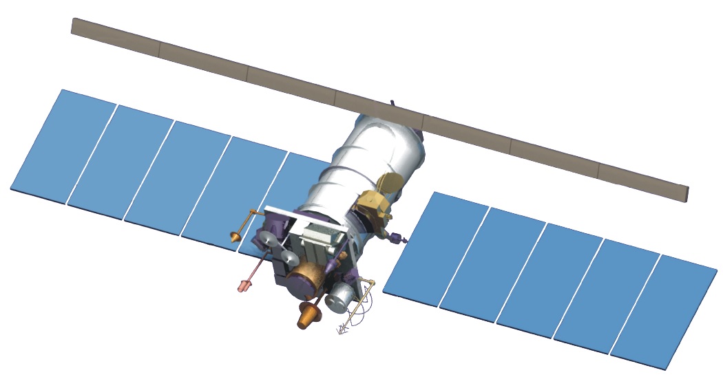
The defining characteristics of the Meteor-M #2 satellite is a large cylindrical satellite body, two deployable sun-tracking solar arrays, a large deployable synthetic aperture radar antenna and a rectangular payload deck that hosts the majority of the instruments and instrument apertures of the satellite being pointed to Earth for observations. The satellite bus shares commonality with the Resurs Earth observation spacecraft.
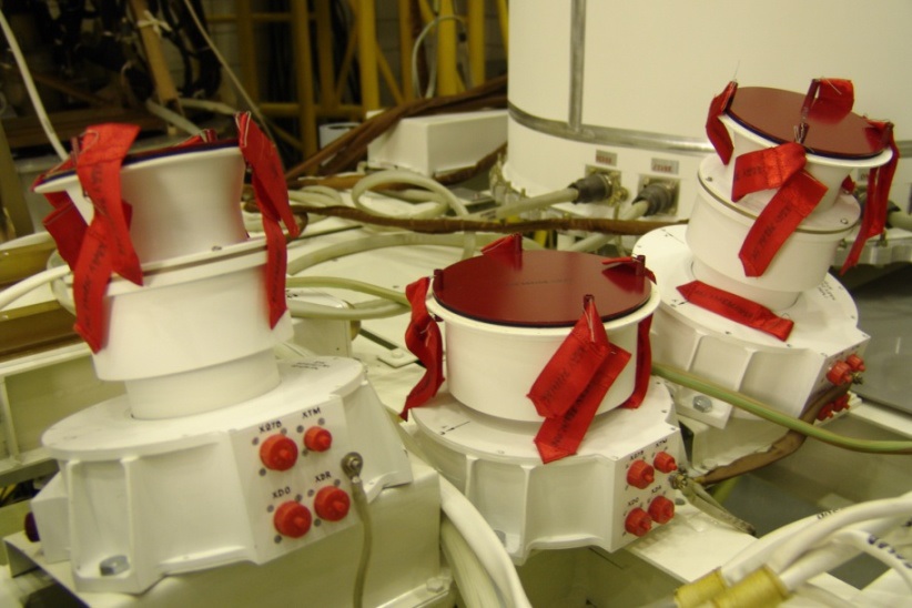
For precise Earth observation, Meteor-M requires precise attitude control. Therefore, star trackers are used for precise attitude determination and reaction wheels are used for attitude actuation. Meteor-M employs BOKZ-M star trackers build by IKI to identify and track star patterns to accurately calculate the vehicle’s three-axis attitude using an onboard algorithm. The star tracker weighs about four Kilograms, is 37 by 23 by 23 centimeters in size and operates at a data update frequency of 0.3Hz (one update every three seconds). The star trackers can support spacecraft slew rates of up to 0.2°/s. CCD detectors are used by the star trackers coupled to a power signal processor.
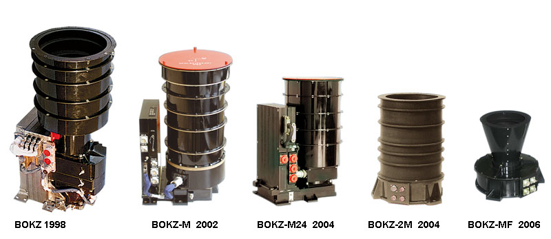
BOKZ Star Trackers
The system can tolerate artificial objects in the field of view and delivers a three-axis attitude solutions at an accuracy of 2/20 arcsec on all axes. The satellite also uses secondary attitude determination sensors as a backup and during sun-exclusions on the star tracker. Overall, Meteor-M achieves a pointing accuracy of 0.1° with an angular drift rate of 1/2000°/s.
A hypergolic propulsion system is used for orbit adjustment maneuvers and orbit maintenance. Meteor-M #2 features two deployable solar arrays attached to the main cylinder of the satellite platform. Each array consists of five panels for a total solar array span of 14 meters and an array area of about 23 square meters. The arrays are rotated by the Solar Array Drive Mechanism that uses sun-sensor data to keep the arrays pointed at the sun while the satellite maintains an Earth pointing attitude. The solar arrays deliver 2,000 Watts of electrical power that is fed to onboard batteries for storage and distribution to the various subsystems of the spacecraft.
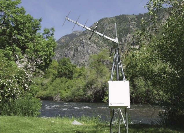
Example of a Data Collection Platform
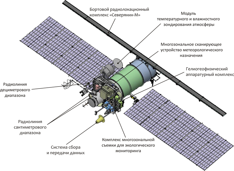
Meteor-M #2 uses a communications system that complies with standards of the World Meteorological Organization. The system includes a multi-frequency transmission system to allow downlink of instrument data using LRIT (Low Rate Information Transmission) and HRIT (High Rate Information Transmission). An X-Band Terminal is used for the transmission of high-rate data at a selectable transmission rate of 15, 31, 61 or 123 Mbit/s at a frequency range of 8.025 to 8.400 GHz. The system also includes an L-Band terminal that reaches a data rate of 665kbit/s at a frequency of 1.7Ghz. VHF data transmission at 137MHz is used for the real time downlink of Low-Resolution Multispectral Scanner data in LRPT.
The Meteor-M spacecraft also support the relay of data from worldwide DCPs (Data Collection Platforms). DCPs can be deployed virtually at any location on the globe to provide in-situ measurements of meteorological data that is then uplinked to satellites and transmitted to ground stations for collection, processing and distribution. The DCPs operate in the UHF band at 401/402 MHz and transmit data packets of 250bits at data rates of 400 to 1200bit/s. Over the course of one orbit, the satellite collects about 300KB of DCP data that is downlinked via the 1.7 GHz L-band terminal.
MSU-MR Multi-Channel Scanning Unit
The Meteor-M #2 satellite carries a suite of seven payloads: MSU-MR (Low Resolution Multispectral Scanner for Cloud Cover Mapping), KMSS (Multispectral Imaging System), MTVZA (Microwave Imaging & Sounding Radiometer), IRFS-2 (Infrared Sounding Instrument for temperature and humidity profiles & surface winds), OBRC (Onboard Radar Complex), Radiomet (Radio Occultation Instrument for temperature and pressure measurements), and GGAK-M (Geophysical Monitoring System Suite).
MSU-MR is a 70-Kilogram Multispectral Scanning Payload that covers six spectral bands for global and regional cloud cover monitoring and sea and land surface temperature measurement. The instrument covers one visible spectral band, one crossover band and four infrared bands. The visible channel covers a band of 0.5-0.7 µm, the Visible-Near-Infrared channel 0.7-1.1 µm, the short-wave IR channel 1.6-1.8 µm, the mid-wave IR channel 3.5-4.1 µm and the two thermal infrared channels cover 10.5-11.5 and 11.5-12.5 µm.
The instrument operates at a scanning angle of 54° covering a 2,800-Kilometer ground swath with a spatial resolution of 1 Kilometer and an angular resolution in all channels of under 1.4mrad. The temperature measurement error in the IR channels is less than 0.5 Kelvin at an operational radiation temperature range of 212 – 313 K. The instrument is operated continuously, generating a steady stream of data at a rate of 660kbit/s.
KMSS Instrument
The KMSS Multispectral Imager consists of three pushbroom imagers covering the visible and infrared spectral regions for surface monitoring applications. Two of the three cameras have a 100-millimeter focal length (MSU-100) and one has a focal length of 50 millimeters (MSU-50). The MSU-100 is 21 by 20 by 20 centimeters in size with a mass of 2.9 Kilograms while the MSU-50 is smaller, being 21 by 20 by 14 centimeters in size with a weight of 2.3kg.
The cameras are equipped with identical CCD detectors and lenses but use different filters. The MSU-100 covers three spectral bands: 535-575, 630-680 and 760-900 nanometers while the MSU-50 covers the following VIS bands: 370-450, 450-510, 580-690nm. MSU-100 has a field of view of 31° while the MSU-50 has a wider FOV of 62°. The two MSU-100 Cameras are installed at a 14° angle in cross track to acquire images of adjacent regions to create a cumulative swath width of 960 Kilometers while the MSU-50 alone covers a 940km swath.
Earth Observation Data Products provided by KMSS are combined images of all three cameras generated during ground processing.
The MTVZA-GY instrument is a passive 29-channel Microwave Radiometer gathering radiometric brightness data across a wide ground swath to deliver data on atmospheric, oceanographic and selected land parameters on a global scale including cloud structure, sea surface winds, rain rates, cloud water, precipitation, soil moisture, etc.
The instrument consists of a large rotating main reflector and an Instrument Support Structure facilitating the RF electronics and sensors as well as the spin mechanism and support systems. MTVZA weighs 90 Kilograms, requires 80 Watts of power and a data rate of 35kbit/s. The operating frequencies of the instrument cover the transparent atmospheric range, the oxygen absorption lines and the water vapor absorption range.
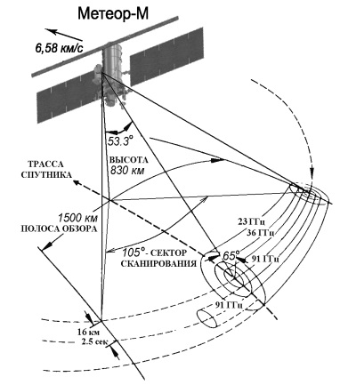
A conical scanning geometry is utilized. The 65-centimeter parabolic reflector rotates along the vertical axis of the instrument at 24 revolutions per minute. The off-nadir angle that defines the cone swept out by the imager is 53.3 degrees which creates an Earth Incidence Angle of 65 degrees with a wide ground swath of 1,500 Kilometers.
MTVZA scans a clear viewing sector of 105 degrees centered on the anti-velocity vector of the spacecraft – scanning behind the spacecraft. The rest of each 360-degree revolution is used for calibration operations. For morning ascending node spacecraft, the instrument observes an area aft of spacecraft nadir while morning descending node spacecraft are scanning an area forward of nadir.
The instrument covers a total of 29 channels with frequencies of 10.6 GHz to 183.31 GHz to retrieve temperature and moisture profiles from ground level up to an altitude of 80 Kilometers. All channels are switched to four feed-horn antennas and a total-power radiometer design is employed to create a better sensitivity. A combination of dual-polarization and single (horizontal) polarization channels are used. The seven 10 to 48GHz channels use direct amplification radiometer technology while the 52-57, 91 and 183 GHz channels use superheterodyne receivers with balanced mixers. The footprint sizes vary with the frequency of the individual channels. The lower frequencies have large footprints that have sufficient overlap in the along-scan direction to achieve a continuous and complete coverage. The high-frequency channels no longer have overlap from one scan to the next causing gaps in coverage, however, the minimum coverage requirement is maintained with the IFOVs of these channels.
Instrument Calibration is accomplished by a cold sky target and a hot load that are being scanned as part of the calibration cycle of each instrument rotation, occulting the feed horns once per rotation.
IRFS-2 Instrument
The IRFS-2 instrument is an infrared sounder built by the Keldysh Center. The instrument consists of an optical unit, a data processing and power supply unit and a radiative cooler that keeps the focal plane at an appropriate temperature to reduce the dark current of the detectors. The optical system is comprised of an interferometric module with a double pendulum interferometer and a radiometer, a pointing module and a calibration module.
IRFS-2 covers a spectral range of 5 to 15 µm at a spectral resolution of 0.4cm^-1. The instrument covers a ground swath of 1,000 to 2,500 Kilometers with a spatial resolution of about 30 Kilometers. The radiometer operates at a temperature accuracy of 0.5K. The instrument covers the carbon dioxide absorption band to obtain temperature profiles, two atmospheric windows for cloud properties and surface parameters, the ozone absorption band for ozone sounding and the absorption bands of water, nitrous oxide and methane for moisture profiles and column amount measurement of these substances.
Overall, the instrument weighs about 50 Kilograms, requires 50 Watts of power and generates 600kbit/s of data.
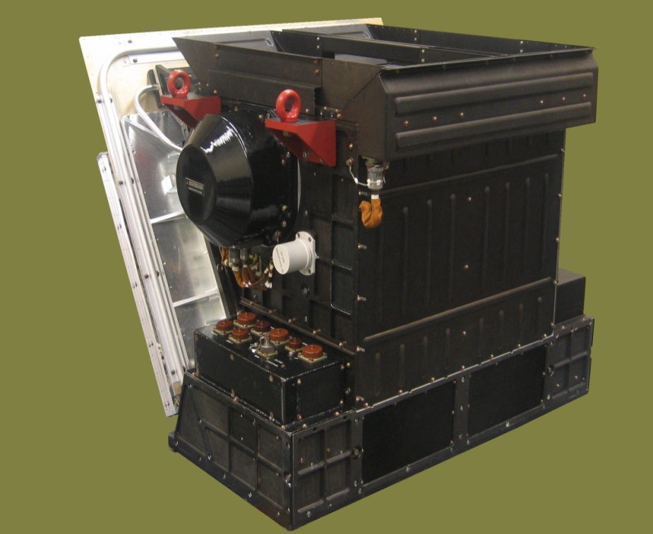
OBRC Payload
OBRC, the Meteor-M Onboard Radar Complex also known as Severyanin, is a Synthetic Aperture Radar operating in the X-Band frequency. Primarily, the radar is used for monitoring sea ice in the polar regions, but radar imagery can also be used for land surface observation for vegetation monitoring and a number of other applications. The radar bounces radar signals off the ground and records the weak echo signal to deduce radar reflectiveness of sites on the ground which differs between the various types of vegetation, water bodies and man-made structures. Overall, the system consists of two main components: the antenna subsystem and the electric unit. The radar antenna consists of seven segments, six of which are deployed after launch with the central segment attached to the zenith-pointing deck of the satellite. The instrument weighs 150 Kilograms and draws 1,000 Watts of power when in operation.
The OBRC instrument operates at a center frequency of 9.623 GHz and an incidence angle range of 25 to 48 degrees. A 450 to 600-Kilometer ground swath is covered by the radar, depending on the observation mode as it can operate in low and medium resolution mode. In low resolution mode, the radar reach a ground resolution of 700 to 1,000 meters while the medium resolution mode leads to images with a spatial resolution of 400 to 500 meters.
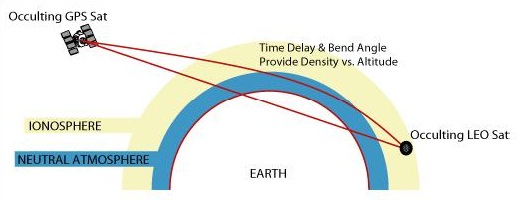
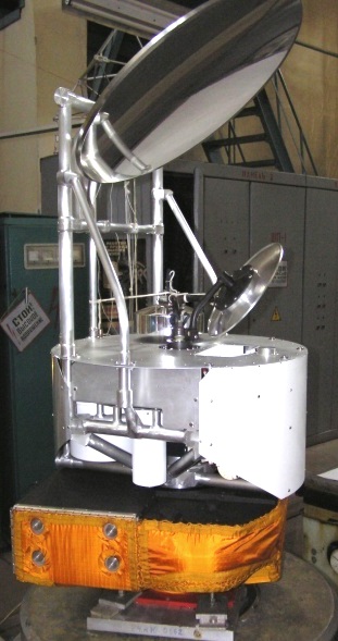
GPS Occultation Measurement Principle
The Radiomet instrument consists of a series of GPS/Glonass receivers for radio occultation measurements that provide atmospheric properties such as temperature at different altitudes, humidity and sounding. The system also allows for space weather measurements such as electron abundance. The instrument consists of several GPS and Glonass receivers to be able to track the signals of several MEO satellites and measure the time delay and bend angle of signals that travel through the atmosphere located in the line of sight of the two spacecraft. These phase delay measurements due to refraction by the atmosphere can be made from the satellite altitude to very close to the surface leading to precise information of the properties of the atmosphere at an accurate vertical resolution.
Radiomet measurements reach a horizontal accuracy of about 300 Kilometers while the vertical resolution is better than 0.5 Kilometers. Approximately 750 soundings will be made by the instrument per day spaced about 820km for each measurement.
GGAK-M is s suite of instruments dedicated to the measurement of geophysical properties consisting of the KGI-4C Radiation monitoring system and the MSGI-MKA electrostatic analyzer.
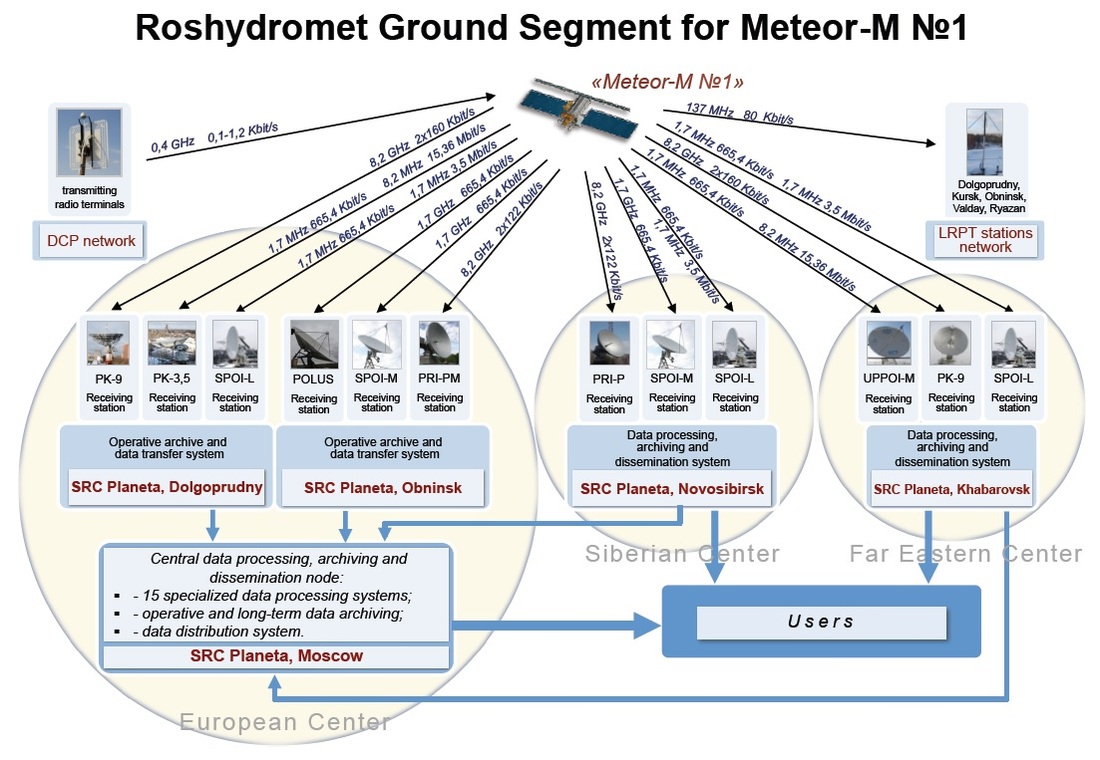
Meteor-M Ground Segment
The KGI-4C system is capable of flux density measurements of electrons and protons at threshold energies of 5, 15, 25, 30, 40 and 90 MeV for protons and 0.17, 0.8, 1.7, 2.0 and 3.2 MeV for electrons. Thee sensor weighs about 12 Kilograms and requires 7 Watts of electrical power.
The MSGI-MKA can detect electrons in the energy range of 0.1 to 15keV, protons at 0.1 to 15keV in a high- and low-sensitivity channel. Integral electron fluxes can be measured up to 40keV. The field of view of each channel is 10 by 10 degrees and 20 by 20° for the integral electron flux channel. Overall, the instrument weighs 5 Kilograms and draws 7 Watts of power.
The Meteor-M satellites use three main downlink stations spread from west to east across Russia: Moscow, Novosibirsk and Khabarovsk. 68 local centers are also used for data downlink and processing operations. Meteor-M data is distributed to the Russian government (e.g. Department of Defense, Emergency Control Ministry) and other institutions for weather forecasting, environmental monitoring and scientific purposes.
