

NOAA 16 Satellite Breakup leaves Dozens of Debris in Orbit

The in-orbit break-up of the NOAA 16 weather satellite left a cloud of dozens of debris in orbit, data released by the Joint Space Operations Center indicates. The debris event was detected on November 25 when ground-based radars sensed a number of debris in the vicinity of the NOAA 16 satellite that had been retired since 2014. Given the behavior of satellites of similar construction, the leading suspect for the debris event is an explosion of the spacecraft battery.
NOAA 16 was in an orbit of 841 by 857 Kilometers when the event occurred and the Joint Space Operations Center became aware of the debris release at around 8:16 UTC on November 25. It took one and a half weeks for data to be gathered on the number and orbital trajectories of the debris. JSpOC released orbital elements for 53 debris on Friday showing a large spread in orbits ranging from 462 by 858 to 829 by 1,278 Kilometers. This indicates that the debris were liberated with significant energy, suggesting either an onboard explosion or a collision between objects. A collision had been ruled out earlier leaving only the scenario of an explosion onboard the satellite which is not unheard of in NOAA satellites and satellites of the Defense Meteorological Satellite Program.

Analysis conducted by Dr. T.S. Kelso shows the NOAA 16 debris event occurred at approximately 7:20 UTC on November 25.
This marked the second large debris event of 2015 involving NOAA/DMSP satellites after the DMSP F13 satellite suffered a battery explosion in February that was preceded by a sudden temperature spike in the satellite’s power system. Initially, 43 debris were cataloged but the total number of liberated debris rose to 160 in the months that followed. It should be noted that only debris of a certain size can be tracked from the ground, small centimeter-sized debris or frozen fluid droplets that could also harm satellites can not be monitored from the ground. More debris from the NOAA 16 satellite are likely to be detected in the coming weeks and months.
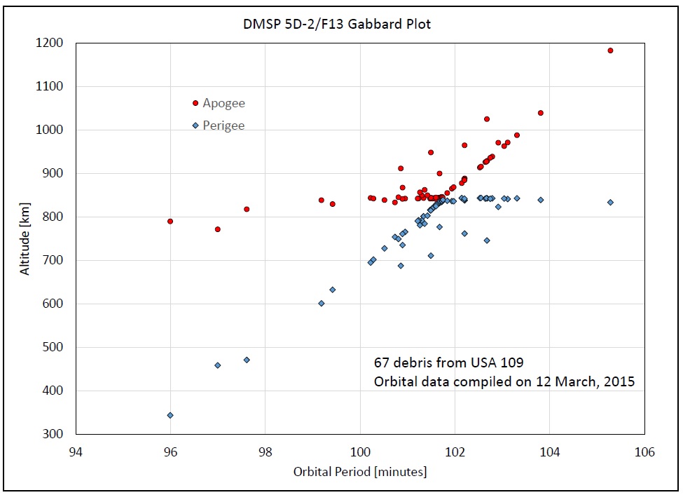
The DMSP F13 break-up left a debris could with a similar spread to that created by NOAA 16, extending more than 300 Kilometers above and below the pre-breakup orbit. The debris could is mostly symmetric in altitude – a similar number of debris was thrown into higher and lower orbits. Also, about half the debris were put into orbits with inclinations higher than the parent object, and half into orbits with lower inclinations.

The bulk of NOAA 16 debris reside in orbits that will be very slow to decay and may last several decades. This altitude regime had already become cluttered with debris from historical break-ups which is particularly unfortunate given the importance of 850km Sun Synchronous Orbits for remote sensing and meteorological satellites.
In 2004, the DMSP F11 satellite suffered a breakup that created 84 trackable debris. The NOAA 8 satellite launched in 1983 suffered an onboard failure in December of 1985 leading to the release of six pieces of debris into orbits between 750 and 850 Kilometers. The suspected cause of the debris event was an overcharge of the battery resulting in a minor explosion of the battery. Two pieces of debris liberated from the NOAA 6 satellite in 1992 and 1995 and NOAA 7 suffered two debris events in 1993 and 1997 releasing two and three objects, respectively.
Studies of telemetry collected during the event involving DMSP F13 showed it was caused of an explosion of one of the satellite’s Nickel-Cadmium batteries. Engineers concluded that a compromised wiring harness inside a battery charger was responsible and that six other DMSP satellites were using the same faulty part and could suffer the same fate, holding the potential for the release of hundreds of additional debris into this highly frequented orbital trajectory.

NOAA 16 was built by Lockheed Martin as part of the fifth generation of the Polar Orbiting Environmental Satellites that deliver an uninterrupted flow of global environmental information for operational applications including meteorology. Weighing in at 2,230 Kilograms, the NOAA 16 satellite hosted five instruments comprised of an Advanced Very High Resolution Radiometer, a High Resolution Infrared Sounder, an Advanced Microwave Sounding Unit, a Solar Backscatter Ultraviolet Radiometer and a Space Environment Monitor plus Search and Rescue Tracking Systems.
As the second in the fifth generation of POES satellites, NOAA 16 was launched on September 21, 2000 from Vandenberg Air Force Base atop a Titan-II rocket. Entering orbit, the satellite completed a six-month commissioning phase and was declared operational in March 2001 starting out in an 870-Kilometer Sun Synchronous Orbit. Due to an issue with the antenna system of the satellite, NOAA 16 deactivated its Automatic Picture Transmission function and relied on High Resolution Picture Transmission for realtime imagery downlink.
The satellite handed primary duties off to NOAA 18 in 2005 and entered a backup position in which it continued delivering data. On June 6, 2014 the signal from the satellite was lost after a major spacecraft anomaly. NOAA 16 was officially decommissioned on June 9 after it was determined that recovery of the mission was not possible. Over the course of its 13-year service life, NOAA 16 made 70,655 orbits around Earth, surpassing its three-year design life by a decade.
