Indian Regional Navigation Satellite System
IRNSS – the Indian Regional Navigational Satellite System is a regional satellite navigation system being developed by the Indian Space Research Organization. The system has the overall goal of giving India independent access to accurate navigation and timing data on a 24×7 basis.
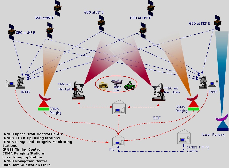
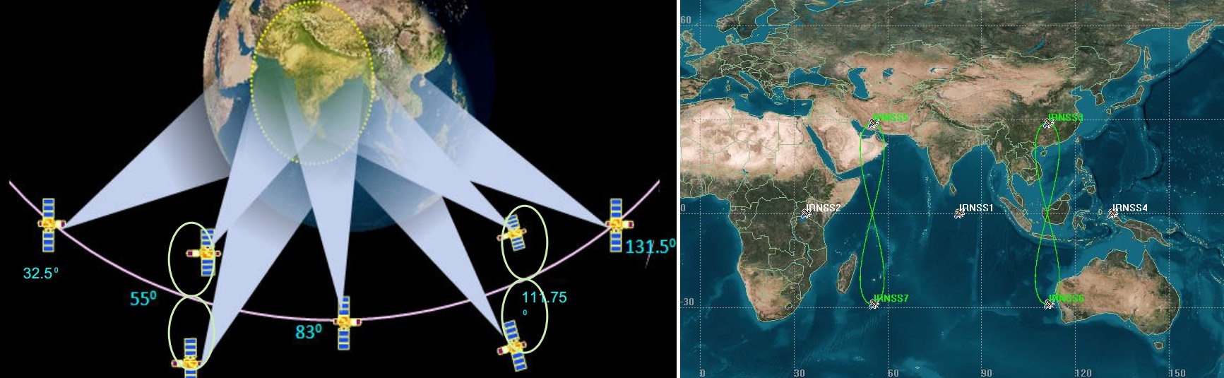
The IRNSS project was approved in 2006 and is baselined for a total of seven satellites. In its fully operational configuration, the IRNSS constellation will consist of three satellites in Geostationary Orbit and four spacecraft in Geosynchronous Orbit inclined 29 degrees to the equatorial plane. The system is designed to be compatible with the US Global Positioning System and Europe’s upcoming Galileo constellation using navigation signals in S-Band and at L5. The deployed constellation will only cover India and surrounding regions with high-accuracy services available about 1,500 Kilometers beyond the Indian territory.
The three GEO satellites will be stationed at 32.5, 83 and 131.5 degrees while the GSO spacecraft will be in two different orbits inclined 29 degrees with longitude crossings at 55 and 111.75 degrees. Each of the two GSO orbital planes contains two satellites spaced 180 degrees in their orbit.
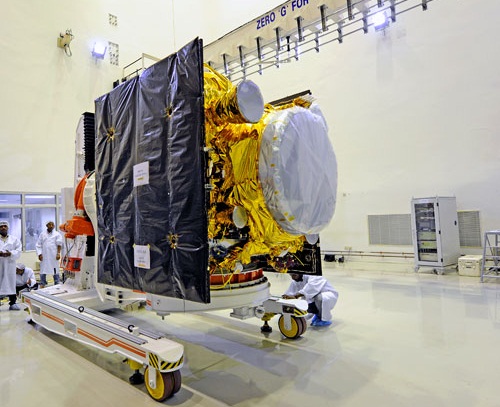
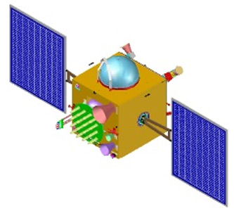
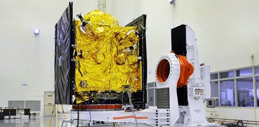
The IRNSS-1 satellites have been designed and developed by the Indian Space Research Organization, ISRO. It is based on the I-1K Satellite Bus. The Spacecraft Bus is 1.58 by 1.5 by 1.5 meters in size with a dry mass of 614 Kilograms. Fully fueled, the spacecraft weighs 1,425kg.
The satellite features two deployable solar panels that are equipped with Ultra Triple Junction solar cells that generate a total power of 1,660 Watts. Power storage is accomplished with a single 90 Amp-hour battery, an avionics system controls power distribution and battery charging. The satellite platform is three-axis stabilized using a zero momentum system consisting of reaction wheels, magnetic torquers as well as attitude control thrusters. A total of 12 thrusters are mounted on the vehicle. Navigation data is acquired by Sun and Star Trackers as well as an inertial measurement unit. The satellite provides precise pointing capability.
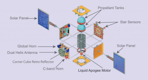
The main propulsion system for large orbit adjustments and apogee maneuvers consists of a Liquid Apogee Motor, LAM. It provides a thrust of 440 Newtons and uses Mixed Oxides of Nitrogen as fuel and Unsymmetrical Dimethylhydrazine as oxidizer. The engine operates and an mixture ratio (O/F) of 1.65 and has a nozzle ratio of 160. The engine’s injector is a co-axial swirl element made of titanium while the thrust chamber is constructed of Columbium alloy that is radiatively cooled. The engine is certified for long firings of up to 3,000 seconds. The Propellants are stored in spherical tanks that are pressurized with Helium.
The twelve 22-Newton attitude control thrusters are connected to the same propellant system and also feature the basic design with a Titanium alloy injector and Columbium nozzle. The thrusters operate in blowdown mode at a chamber pressure of 0.68 Mpa. The thrusters have an area ratio of 100.
The heart of the satellite payload is a highly accurate Rubidium atom clock that is used to generate navigation signals. The payload of the satellite operates in L5-band at a center frequency of 1176.45 MHz and a bandwidth of 24MHz and in S-Band at 2492.028 MHz with a bandwidth of 16.5MHz.
The Spacecraft will support Standard Positioning Service that is open to all users as well as Restrictive Service with high accuracy that is only provided to authorized users. The system will provide an accuracy of 10 to 20 meters.
In addition to the navigation payload, the satellite is equipped with a ranging system that is used to precisely calculate the vehicle’s range. A C-band transponder is used to determine accurate range data with an uplink frequency of 6700 to 6725 MHZ (right-hand polarized) and a downlink at 3400-3425MHz (left-hand polarized). For even more precise data, the satellite carries Corner Cube Retro Reflectors that can be used for laser ranging that will yield extremely accurate data.
Each IRNSS satellite has a life expectancy of 10 years. Once fully deployed, the IRNSS constellation will provide navigation service to India and surrounding areas as far as 1,500 Kilometers from the primary service zone that is enclosed by a rectangle of a latitude of 30 degrees south to 50 degrees north and longitude of 30 degrees east to 130 degrees east.
The satellite constellation will be supported by a large ground segment of core operations centers as well as 21 ranging and tracking stations positioned all across India.
The IRNSS Navigation System will serve a number of applications. It will be used for terrestrial, aerial and marine navigation, precise timing, mapping and geodetic data acquisition, disaster management and vehicle tracking and fleet management.
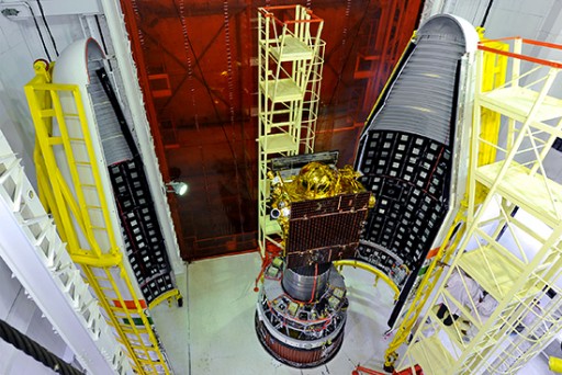
IRNSS-1A was launched in July 2013 and has since then completed extensive testing and acceptance checks to make sure the spacecraft was operational and its navigation signals worked as expected before allowing the rest of the constellation to launch. It operates from Geosynchronous Orbit at 55° East, inclined 28°. IRNSS-1B launched in April 4, 2014 and operates from a Geosynchronous Orbit, also at 55°E with a 180° phasing to IRNSS-1A. The 1C satellite headed into orbit in October 2014 and builds the centerpiece of the constellation in Geostationary Orbit at 83° E. Launching in March 2015, IRNSS-1D aimed for the 111° GSO slot and is currently (Jan 2016) found in a 30° orbit at 108°.