GCOM-C1 Satellite
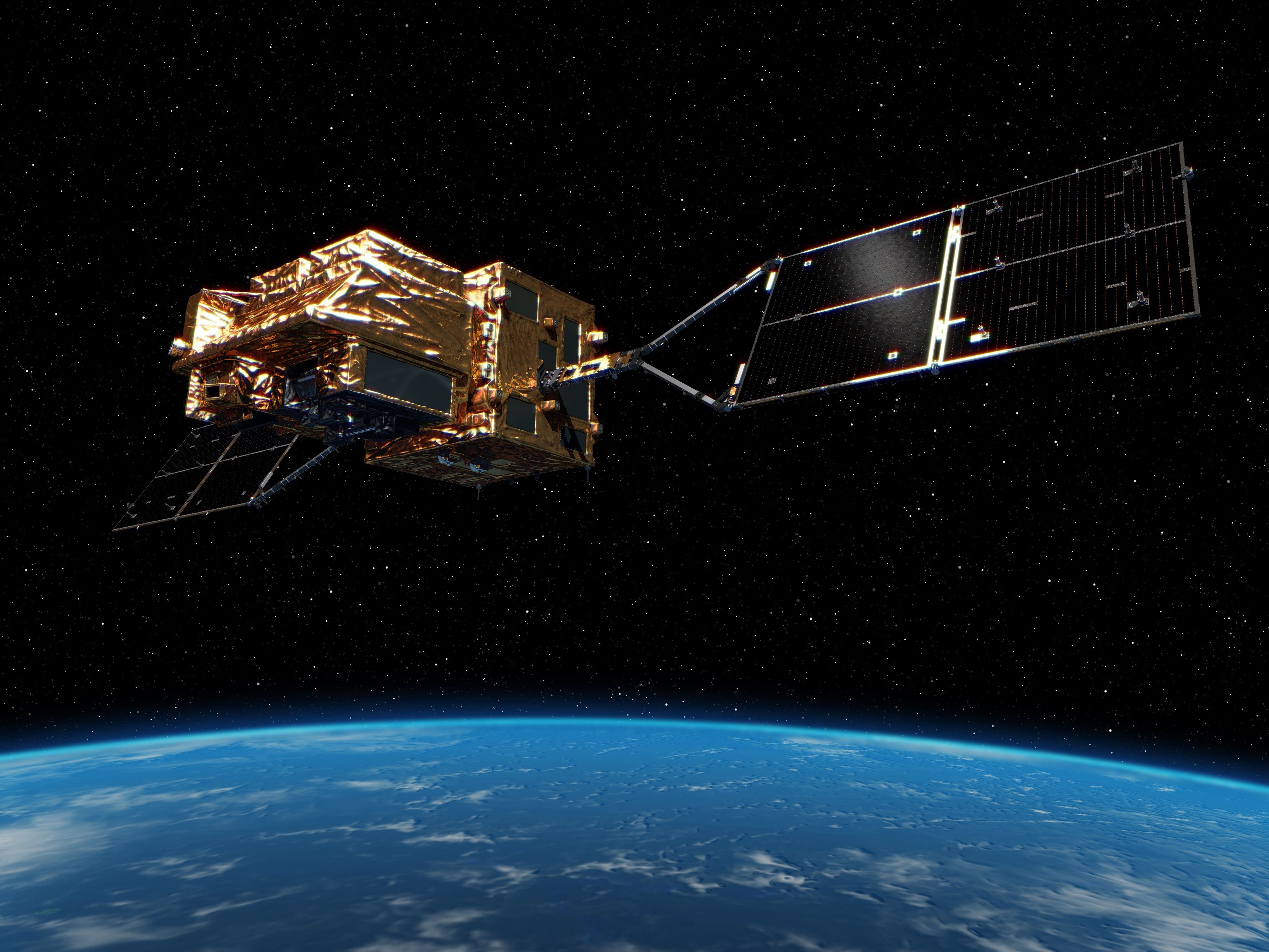
GCOM-C, the Global Change Observation Mission for Climate, also called Shikisai, is a Japanese Earth Observation satellite outfitted with a multi-channel imaging instrument to contribute to surface and atmospheric measurements of relevant parameters for an improved understanding of the carbon cycle and Earth’s radiation budget. Launching in late 2017, GCOM-C will operate for at least five years, hosting a Second Generation Global Imager covering a range of spectral channels from the ultraviolet into the infrared and collecting a complete image of Earth every two to three days.
The Global Change Observation Mission was initiated by the Japan Aerospace Exploration Agency (JAXA) as the country’s contribution to the Global Earth Observation System of Systems (GEOSS) – a multinational, multi-agency effort to enhance the relevance of Earth observations on global issues of our day. The GCOM program operates two types of satellites – GCOM-W (Shizuku) looking at water and energy circulation and GCOM-C (Shikisai) with emphasis on climate-related parameters of the carbon cycle and radiation budget. Three satellites of each variant are planned.

GCOM-W1 launched in 2012 and its mission is focused on Earth’s water cycle, employing an Advanced Microwave Scanning Radiometer to observe atmospheric water vapor, precipitation events, ocean winds, sea water temperature, water levels on land and snow depth.
GCOM-C is considered a follow-on program to the ADEOS-II satellite that failed after less than a year of operation in 2003 and the multi-national Aqua mission led by NASA and still operational after 15 years in orbit (as of 2017). The overall objective is to contribute to global change research through the collection of long-term (>10 years) observations with cross-calibrated sensors. GCOM-W and GCOM-C are planned to operate as a dual-satellite constellation over three generations, launching three GCOM-W satellites to provide coverage through at least 2025 and deploying three GCOM-C spacecraft for data collection through 2027 after the GCOM-W series got a head start.
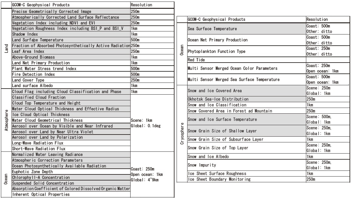
Data delivered by GCOM will be employed in a twofold fashion – long-term records established by the system will feed into numerical climate models while the constantly updated data stream from the satellite finds application in a number of operational areas such as weather forecasting and disaster monitoring & mitigation. Specifically, GCOM is expected to provide insight into global warming over a span of 27 years from ADEOS and 21 years from ADEOS-II, deliver data on global forest dynamics as well as snow and ice changes which are areas of constant motion on the surface of the planet; spectral imagery from the satellites will also be used to clarify the sources and sinks of greenhouse gases.
Furthermore, data from GCOM can be useful for a large number of areas such as ocean biology (Chlorophyll, suspended solids, visible dissolved organic matter), ocean physics (winds & temperature), vegetation (vegetation distribution, leaf index, biomass, land surface temperature & emissivity, soil moisture), cryospheric science (sea ice concentration, snow / ice cover). Given the need for cross-calibration and the desire to establish a record without gaps, GCOM will launch satellites with at least one year of overlap between missions.

The design phase for GCOM-C as a counterpart to GCOM-W started in mid-2009 and by the end of that year the Japanese Space Activity Commission green-lighted the project to enter the design and assembly stage.
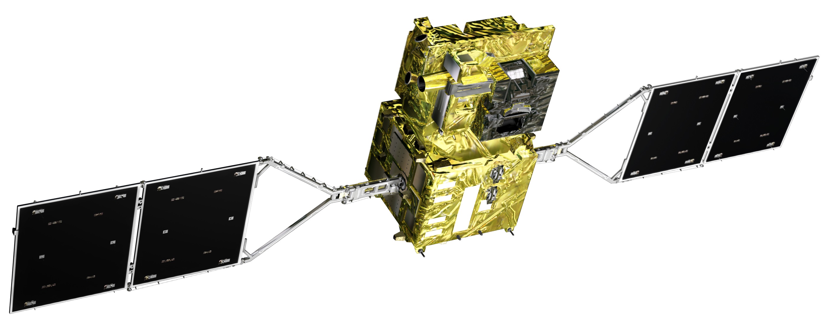
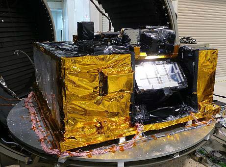
The GCOM-C1 satellite uses a box-shaped satellite bus module to which the instrument module and a pair of two-panel solar arrays are attached, giving the satellite a deployed size of 4.6 by 16.3 by 2.8 meters. It has a mass of 1,950 Kilograms – 1,374kg for the bus, 400kg for the instrument and 176kg of propellant for orbit maintenance.
GCOM-C1’s solar-tracking arrays deliver a nominal power of 4,250 Watts (at EOL) and the satellite employs a three-axis stabilization system relying on three Star Trackers, sun sensors, Earth horizon sensors and an inertial platform for attitude determination and reaction wheels & magnetic torque rods for attitude actuation with the thrusters available to assist in safe mode attitude control.
The communications system of the GCOM-C1 satellite employs a combination of S- and X-Band for communications – S-Band is used for telemetry downlink and command uplink at data rates of 29.4kbit/s and 1Mbit/s for telemetry downlink and 4kbit/s and 125kbit/s for command uplink. The X-Band terminal is used for the downlink of science data at a data rate of 138.76Mbit/s. When passing over Japan, science data is downlinked in real time to the Katsuura or Saitama ground stations while stored science data collected over the course of the orbit is played back through the SAT (Kongsberg Satellite Services) Station in Svalbard, Norway.
GCOM-C operates from a Sun Synchronous Orbit of 798 Kilometers, inclined 98.6 degrees with a local time of descending node at 10:30.
The single instrument of the GCOM-C satellites is the Second-Generation Global Imager with heritage from the original GLI instrument flown on the ADEOS-II satellite.
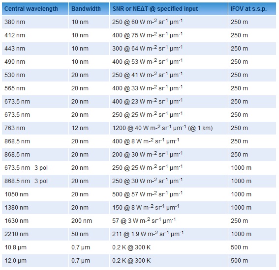
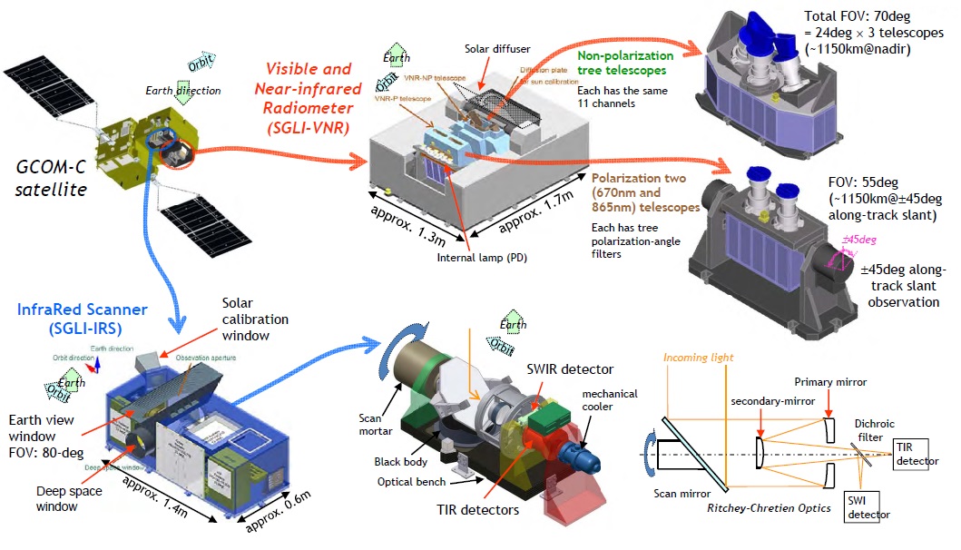
SGLI combines two separate sensors – the Visible & Near Infrared Instrument (VNIR or VNR) and an Infrared Scanner (IRS) – both are mostly independent with their own optical assemblies and electronics units, but are joined on the satellite’s payload module, residing side-by-side on a stable optical bench. In total, SGLI covers 19 spectral channels from the UV spectrum over the visible & near-infrared wavelengths to the thermal infrared spectrum with varying ground resolutions between 250 and 1,000 meters and polarization sensitivity.
SGLI, through its spectral range and sensitivity, can measure ocean color, sea surface temperature, land use, vegetation, snow, ice, clouds aerosols and atmospheric water vapor – addressing all critical objectives for its role under GCOM. Aerosols are a particular focus point and SGLI offers polarization-sensitive channels with three different viewing directions to obtain vertical atmospheric aerosol profiles.
Both VNIR and IRS are scanning instruments but the two use different scanning principles, VNIR being a pushbroom sensor, assembling an image of the ground swath swept out by the satellite’s orbital motion while IRS uses a mechanical whiskbroom scanner to sweep out its cross-track swath – the major difference between the two being the size requirements for the detectors.
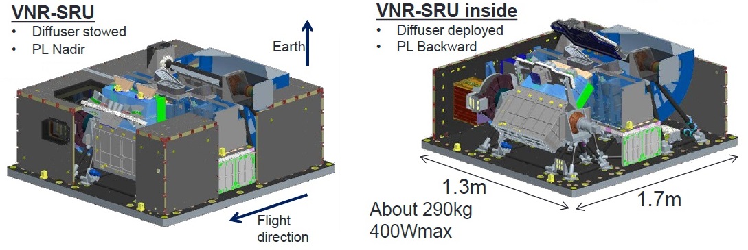
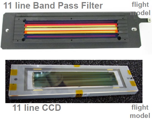
The 1.3 by 1.7-meter VNIR covers 13 spectral channels in the ultraviolet, visible and near-infrared spectral region from 375 to 878.5 nanometers – eleven channels are termed VNIR-NP for non-polarized and two channels are called VNIR-P and are polarization sensitive, providing three polarization angles of 0, 60 and 120°. The non-polarization channels employ three 24-degree pushbroom telescopes to achieve the desired 70° field of view, corresponding to a ground swath of 1,150 Kilometers.
All NP channels, with the exception of the 763nm channel, have a ground resolution of 250 meters, though pixel-binning is employed when flying over the oceans to reduce data volume, limiting offshore resolution to 1,000 meters. Each VNIR telescope hosts CCD line detectors with 2,000 pixels in line.
To add to the satellite’s overall data set, key VNIR channels (673 & 868.5 nm) are observed with low and high dynamic range settings simultaneously. The improvement of resolution from 1km for GLI to 250m for SGLI will allow GCOM to study the influence of human activity on the Earth’s environment on the same extended time scale as the mission’s climate observations, putting anthropogenic factors into a new context.
The VNIR-P polarimeters reside within a pair of pushbroom telescopes and cover the 670 and 865 nm channels in the three polarization angles outlined above and over a ground swath of 900 Kilometers (55° FOV). For aerosol observations, a tilting operation by +/-45° around the Y-axis is needed to set up the proper scattering angles for the optical observation of suspended aerosols in the atmosphere. The polarimetric channels use 1,000-pixel CCD lines.


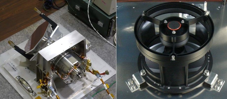
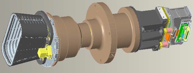
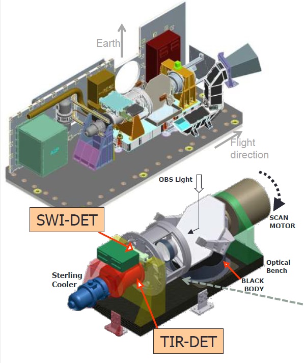
The six-channel IRS instrument – 0.6 by 1.4 meters in size – uses a mechanical scanning assembly to sweep out a 1,400-Kilometer swath width (80° cross-track FOV) and direct light into an infrared telescope assembly with detectors sensitive in the short and thermal infrared range from 1,050 to 2,210 nanometers (SWIR) and 10.8 and 12.0 micrometers (TIR).
IRS uses a Ritchey-Chretien arrangement for its optical assembly, a special version of the conventional Cassegrain telescope with a hyperbolic primary mirror and a hyperbolic secondary mirror to eliminate off-axis optical errors and create high-quality imagery.
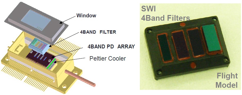
A dichroic filter separates the SWIR from the TIR wavelengths and directs the two beams toward their detectors – the SWIR channels use Indium-Gallium-Arsenide photodiodes cooled to -30°C by a Peltier Cooler Assembly to reduce dark currents while the TIR detectors consist of a Mercury-Cadmium-Telluride array built in France, cooled to -218°C by an active Stirling cooler.
The SWIR3 channel (1,630nm) operates at a ground resolution of 250m while all other SWIR channels obtain imagery at 1km resolution; the two wide-band TIR channels deliver imagery with a 500-meter ground resolution, but they can be switched into a 250m resolution mode for a portion of each orbit when passing high-interest areas.
As with any radiometric instrument, calibration is paramount to keeping GCOM-C’s measurement accuracy constant over extended periods of time and thus a multi-pronged approach is taken to ensure multiple calibration sources are available.
The VNIR instrument hosts an internal lamp with known spectral properties for spectral calibration and relies on a solar diffuser and lunar observations as external calibration targets with well known and constant spectral properties. Additionally, masked pixels and nighttime observations are used to assess dark current variations.
The SWIR channels also use an internal lamp, solar diffuser and lunar observations for spectral calibration while dark currents are assessed via a deep space window serving as a cold reference target. TIR employs a black body at known temperature as a hot calibration target and deep space as cold reference. The IRS scanning mirror passes the internal lamp, black body and deep space window once per scan, allowing for continuous calibration data to be captured.