
Identifying the classified NROL-42 Satellite

NROL-42, in all likelihood, is the second Trumpet-Follow-On-2 satellite operated by the U.S. National Reconnaissance Office as part of its fleet of signals intelligence spacecraft tasked with vacuuming up vast amounts of satellite communications, intercepting telemetry signals from missiles and characterizing ground sites of interest based on radio activity.
Trumpet satellites, also known as Advanced Jumpseat, operate in a highly elliptical orbit to complement satellites in Geostationary Orbit by providing improved coverage in the high-latitude regions, also carrying sensors for the detection of ballistic missile launches to patch up a blind spot of Geostationary missile monitoring satellites.
The United States National Reconnaissance Office is an intelligence agency tasked with the design, construction and operation of all U.S. reconnaissance satellites and delivers satellite intelligence to other three-letter intelligence agencies including signals intelligence for the NSA, image reconnaissance data to the NGA and measurement & signature intelligence to the DIA. Established in 1961, the NRO has been shrouded in great secrecy and its existence as an agency was only first acknowledged in the early 1990s.
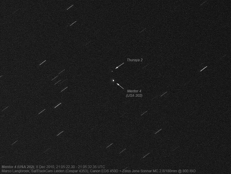
As an intelligence agency, the NRO goes through great lengths to keep its activities secret, therefore the identity of all NRO satellites is classified. However, it is possible to identify the nature of satellites taking into account their launch site, launch window, launch vehicle type and ascent path. Sometimes, hints can be found in mission logos and, after launch, most satellites are typically tracked in orbit by a worldwide network of observers, revealing from where they operate, and often what they are tasked with.
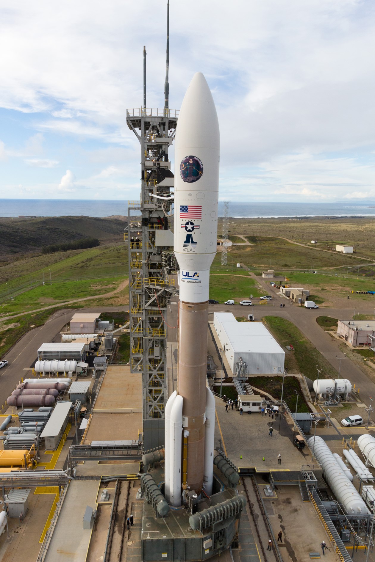
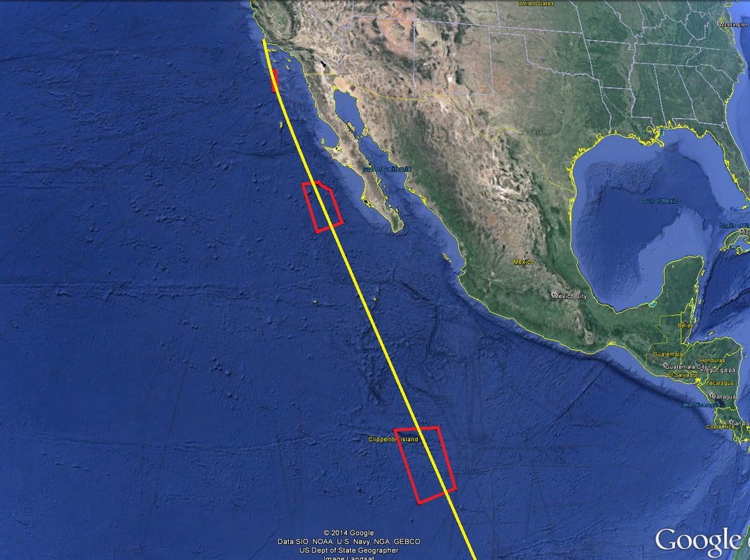
Some cases are easier to solve while other NRO missions can only be narrowed down to a number of candidates. NROL-42 is one of the easier cases to solve, starting with the Atlas V 541 launch vehicle that has so far flown only four missions – NASA’s MSL Curiosity Rover, NROL-67, NROL-35 and GOES-R. All these launches with the exception of NROL-35 occurred from Cape Canaveral, putting NROL-42 in the same group as the NROL-35 satellite, being only the second 541 launch from Vandenberg.
NROL-35 was suspected before launching to be inaugurating a new type of Trumpet Signals Intelligence Craft. Hobbyist satellite trackers spotted the satellite in an orbit of 1,120 by 37,560 Kilometers, 63.5° – in-line with the previous generation of Trumpet satellites. Additional confirmation came through the U.S. Air Force that reported some time after the NROL-35 launch that the third HEO Payload of the Space-Based Infrared System (SBIRS) had successfully been launched on a host spacecraft operating in a Highly Elliptical Orbit (HEO).
NROL-42 uses the same launch vehicle configuration and launch site as NROL-35 and will follow a very similar launch path, leaving little doubt on its identity as the next Trumpet Signals Intelligence bird. Also, Northrop Grumman reported in June 2015 that the SBIRS HEO-4 payload had been shipped for integration with its host, in-line with a two-year satellite assembly & testing schedule leading up to launch.
Signals Intelligence, along with image reconnaissance, are the two major cornerstones in modern intelligence-gathering and, as satellites have taken over much of the world’s secure and open communications, space-based intelligence collection has become a major focus among the large space-faring nations. The U.S. in particular has a long history of in-space signals collection, starting out in the late 60s when the NRO launched its first series of communications intelligence craft known as Canyon, featuring ten-meter dishes to listen in on radio communications from a near-Geostationary Orbit.
Six Canyon satellites reached orbit through 1977 and listened in on microwave and VHF communications, also providing a location of the signal source through triangulation from their non-stationary, but synchronous orbits. A complementary program active in Geostationary Orbit was Rhyolite (later re-named Aquacade) that launched four satellites in the 1970s, optimized to capture telemetry signals from Soviet and Chinese missiles and re-entry vehicles as well as microwave emissions from the Soviet Union.
To provide full coverage of the Soviet Union, including its northern regions, satellites in Geostationary or near-GEO orbit were found to be insufficient due to extremely low elevation for the northern latitudes. This led to the inauguration of the Jumpseat program that deployed a constellation of satellites into highly elliptical Molniya orbits peaking over the northern hemisphere so that at least one satellite was actively listening over the northern regions at any given time, capturing radar signals and microwave communications.
Around half a dozen such satellites were launched from 1971 through the mid-80s (numbers differ among analysts due to similarities between Jumpseat and the Space Data System).
The Canyon satellites were followed by Program ‘Vortex’ in the late 70s through the 80s with five satellites being deployed to orbit, featuring larger, 38-meter diameter dishes. Later re-named Mercury, the original Vortex satellites were extremely long lived and continued supplying signals intelligence into the 2000s. Two Advanced Mercury satellites were launched into Geostationary Orbit in 1994 and 96 to continue supplying strategic-level communications intercepts and missile telemetry.
The flagship Orion program was inaugurated in 1985 and to this day continues as the primary NRO intelligence-gathering system in Geostationary Orbit – going through its initial generation with two satellites deployed by the Space Shuttle in 1985 and ’89, followed by a pair of Advanced Orion Satellites orbited by Titan-4 rockets in 1995 and 98 and a third generation starting in 2003 with three launches through 2010; Orion satellites launched in 2012 and 13 are likely belonging to a fourth generation.
The Orion satellites host very large (100-150-meter) antenna dishes to collect multiple signal types across a broad geographic area. Leaked documentation showed the satellites are sensitive enough to collect Wifi signals from networks some 36,000 Kilometers below them.
Additional Geostationary listening assets include the Nemesis Program with the mysterious PAN and CLIO satellites launched in 2009 and 2014 for direct tasking by the CIA and NSA, and the SHARP (SIGINT High Altitude Replenishment Program) for which there is one candidate satellite in orbit, potentially as an Orion follow-on.

Jumpseat, as the primary collection post in Highly Elliptical Orbit, transitioned to Trumpet in the 1990s with three satellites reaching orbit to build a fully functional constellation with each satellite providing around eight hours of coverage per day. A pair of Trumpet-Follow-On Satellites launched in 2006 and 2008 on Delta IV M+(4,2) and Atlas V 411 rockets, hosting the first two SBIRS HEO payloads to take on an additional role of monitoring missile activity in the northern regions to provide advance warnings of threats to U.S. and allied assets.
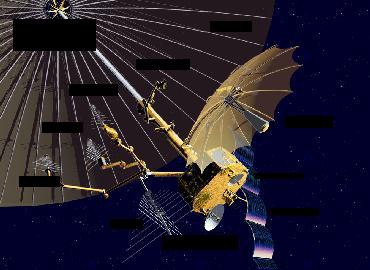
A follow-on to the Trumpet Follow-On (by some referred to as Trumpet FO-2) debuted on the NROL-35 mission in 2014 using the more powerful Atlas V 541 rocket with four instead of one booster and a larger fairing diameter, indicating the satellite mass and size had grown. There have been reports that the FO-2 satellites are substantially different than their predecessors in terms of technology, but their overall mission architecture remains the same – complementing the Orion satellites in GEO by collecting a variety of signals intercepts over the northern hemisphere through a very large deployable antenna.
Speculative information claims that the satellites host large deployable mesh antennas with a diameter of over 100 meters to pick up even faint radio signals over foreign territory to allow insight into activity at military installations and other sites of interest. It is speculated that the Trumpet satellites were manufactured by Boeing.
The Trumpet satellites are operated in a Molniya Orbit which is a highly elliptical orbit at an inclination of 63.4 (in this case) or 116.6 degrees with a period of half a sidereal day (~12 hours) and a high apogee around 37,000 to 40,000 Kilometers. This type of orbit was first used by a series of Russian military communications satellites known as Molniya (Lightning).
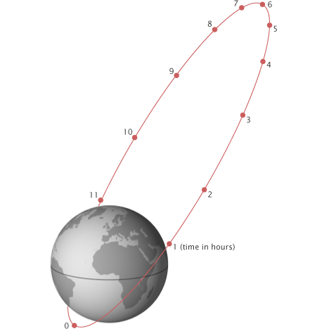
Choosing an inclination of 63.3 or 116.6 degrees allows the satellite to have a constant argument of perigee of 90 or 270 degrees because the orbits are not perturbed by the gravitational field of Earth (J2 term of the Geopotential Model). This allows the satellite to have a constant perigee and apogee location on Earth over the course of its mission – for Molniya orbits, apogee is located above the northern hemisphere.
Relative to Earth, the satellite’s speed is slowest at higher altitudes, meaning that the spacecraft spends the majority of its time around apogee. Communication satellites in Molniya orbits operate for eight hours per orbit centered around the apogee passage. Reconnaissance spacecraft take advantage of the long apogee passage to observe target locations at virtually any point in the northern hemisphere.
The major benefit of a Molniya orbit despite being less energetic than GEO is the coverage of the polar regions which is in many cases not possible from Geosynchronous Orbit due to low elevation angles.
Current NRO programs using Molniya Orbits are the Trumpet electronic intelligence satellites and the HEO Segment of the Satellite Data System which includes spacecraft in Geostationary Orbit and satellites in Molniya Orbits.
