Pleiades Satellite Overview
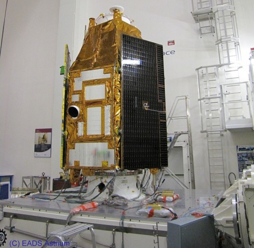
The two Pleiades satellites are very-high-resolution Earth-imaging satellites for military as well as civil and commercial applications. The first Pleiades satellite was delivered to orbit on the second Flight of a Soyuz out of Kourou back on December 16, 2011. Both Pleiades satellites are identical in design.
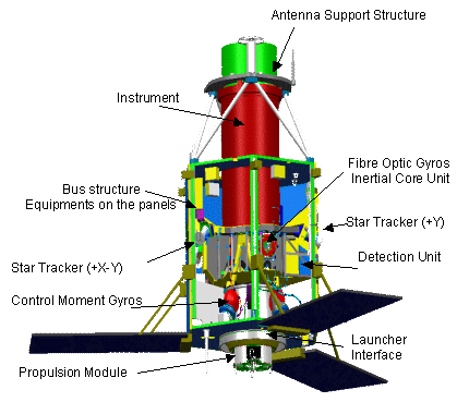
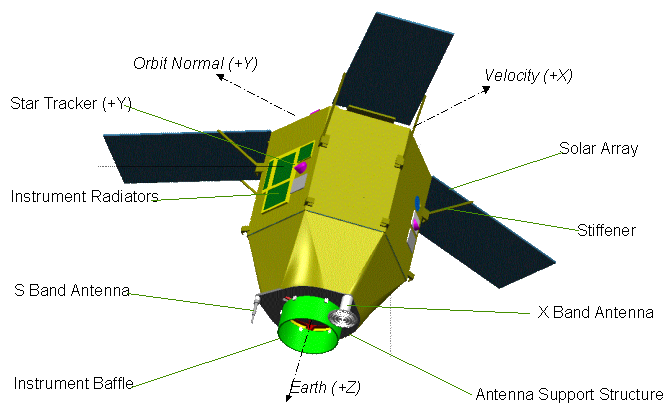
The Satellites were manufactured by Astrium and Alcatel and are based on the AstroSat-1000 Satellite Bus. Pleiades has a liftoff mass of just under 1000 Kilograms with a hexagonal body featuring three deployable solar arrays, spaced 120 degrees. The solar arrays generate about 1500W of power. They are fixed in position and stiffeners move in place after deployment to avoid any motion of the solar arrays that could interfere with image acquisition. Power generation by the solar arrays is supported by slewing the satellite to a sun-tracking attitude when no imaging sequence is active to charge the 150-Amp-hour Li-ion battery of the satellite that provides power to the vehicle during eclipse.
Three star trackers are used to provide accurate attitude determination data. Attitude determination is accomplished with a gyro-stellar system featuring star trackers as well as Fiber Optic Gyros that provide a random drift of 0.002 deg/h, and an angular random walk of 0.0002 deg/root-hour. The star trackers and inertial measurement unit have separate heads and electronics with the optical heads being placed on the instrument to minimize thermal distortion.
The satellite is three axis stabilized and uses four 15-Nms Control Moment Gyros offering excellent yaw, pitch and roll control including slews for image acquisition. A Hydrazine propulsion system is used to maintain the vehicle’s orbit and modify its trajectory.
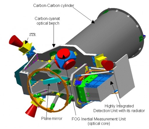
The powerful optical imaging instrument is integrated into the satellite bus. The payload is a Korsch-type telescope with a primary mirror size of 65 centimeters. An internal shutter is used to protect the optics from solar radiation when the satellite is in non-operational phases such as safe modes or orbit adjustments. It operates in a single imagery acquisition mode, simultaneously taking panchromatic and multispectral images. The panchromatic detector consists of five detectors of 6000 pixels with a pixel size of 13µm. The multi-spectral suite uses five 1500-pixel detectors with the same pixel size.
For panchromatic images, the instrument achieves a ground resolution of 70 centimeters for panchromatic images and 2 meters for multispectral imagery. Pansharpened images achieve a resolution of 70cm and interpolated/resampled images have a resolution of up to 50cm. Multispectral imagery cover four bands from visible light to the near-infrared spectrum. The instrument covers a 20-Kilometer ground swath, but the satellite is capable of acquiring 120 by 120-Kilometer image mosaics as well as stereoscopic couples or triplets of 20 by 300 km. Using the Geographical Information System, the payload can achieve a very accurate image localization of under one meter with ground control points.
Pleiades can acquire up to 450 high resolution images per day, storing the raw data inside a 600-Gbit onboard memory before downlinking it to Earth with a data rate of 450Mbit/s. The data handling and transmission subsystem uses a wavelets transform algorithm to compress raw data that is then stored in the memory before being downlinked via an omni-directional 64-degree aperture horn antenna. Pleiades data is being received by two European Defence Centers in Spain and France as well as two civil stations, one in France and one in Sweden.
To ensure that the satellites can receive multiple command uplinks per day, three Stations are used to uplink commands to the spacecraft (Kerguelen Island, Sweden, France). The commands are modified based on operational constraints such as weather conditions in the target areas.
With two satellites, Pleiades can image any given location within 24 hours. Pleiades satellites operate from a 694-Kilometer quasi-circular, sun-synchronous orbit with an inclination of 98.2 degrees. The two satellites will be offset at 180 degrees.
Images provided by Pleiades are used for a number of applications that include civilian and commercial purposes as well as military applications. Imagery is used for land planning, land management, the identification of small features such as vehicles, buildings and roads, hydrology, forestry, Maritime and littoral surveillance, civil engineering and planning of road, rail and oil pipeline corridors. In addition, images can be used to produce flight simulators, to generate high-precision maps and for scientific purposes. Military applications of Pleiades images include intelligence and tactical planning, homeland security purposes as well as crisis management and post-crisis assessments.
Each Pleiades satellite is planned to operate for at least 5 years.