
WNISAT-1R
WNISAT-1R, Weather News Inc. Satellite 1R, is a microsatellite mission for atmospheric and arctic monitoring in a project between satellite builder Axelspace and Weather News Inc. The primary objective of the WNISAT-1R mission is monitoring of the Northern sea routes – tracking potentially hazardous drift ice and tracking sea states to ensure safe passage of ship traffic.
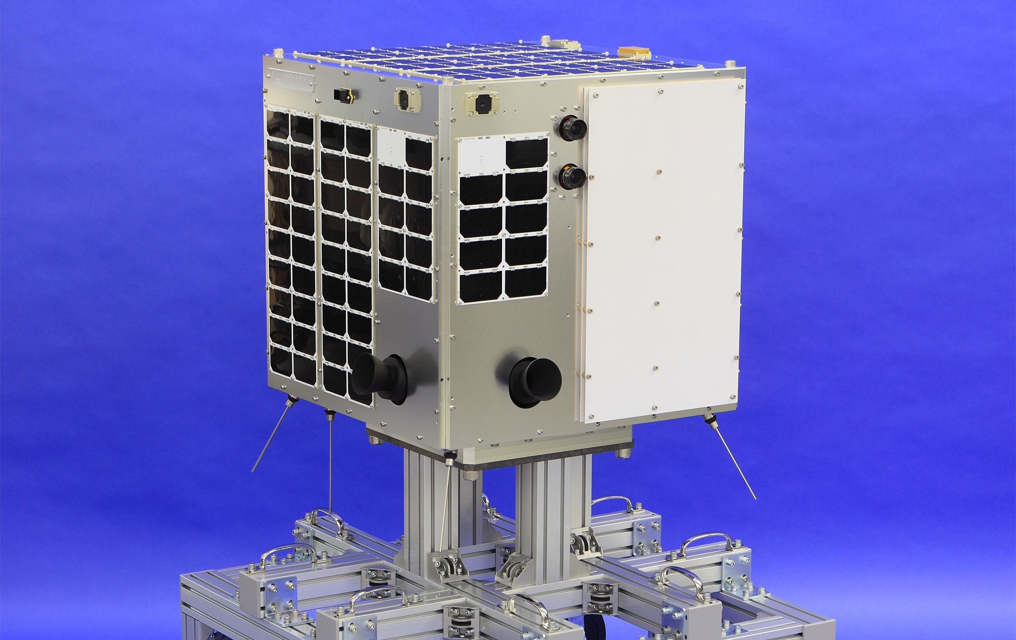
The 52 by 52 by 51-centimeter satellite employs a standardized satellite platform tested under Japan’s Hodoyoshi program and weighs in at around 43 Kilograms. It follows up on the original WNISAT-1 mission of 2013 that used a much smaller and less capable satellite weighing only 10 Kilograms.
The WNISAT project was initiated by Weathernews Inc. of Tokyo – one of the largest full-service weather companies that also provides business support services like advisories for adverse weather events that could affect marine transportation, road, railway, air transportation, retail and distribution, agriculture, construction, communication, large-scale theme parks and others.
WNISAT has the objective of collecting monitoring data for shipping lane customers operating in the Arctic Sea.Shipping lanes through the Arctic Sea are around 30% shorter connecting Europe and Japan compared to traditional routes through the Strait of Malacca and the Suez Canal and only half as long as routes around the African continent. However, they are only open a few months a year due to ice conditions.
The objectives of the WNISAT missions are twofold: a) an Earth-imaging mission of commercial nature collects ice coverage information in the high latitudes using the visible & near-infrared spectral ranges, and b) an atmospheric monitoring mission for environmental applications and research, measuring the density of carbon dioxide in the atmosphere.
The satellite’s observation region shifts based on seasonal requirements – in the summer months, intensified observations are required in the 70-80° latitude range while coverage shifts to the south toward 40-50° in the winter. To satisfy its mission requirements, WNISAT collects several wide-field scenes per day to allow ice fields to be tracked in order to assure safe passage of shipping traffic.
The spacecraft platform is using the AxelSpace Hodoyoshi-1 satellite as a basis, taking a number of flight-proven technologies for power generation, attitude control and communications. The Hodoyoshi project has demonstrated a number of systems such as high-speed X-Band communications, accurate attitude control and Hydrogen Peroxide-based propulsion for orbit control. WNISAT-1R hosts a precise attitude determination and control system with a pointing accuracy of 0.1 degrees; payload data is downlinked via a 10-20Mbps X-Band terminal.
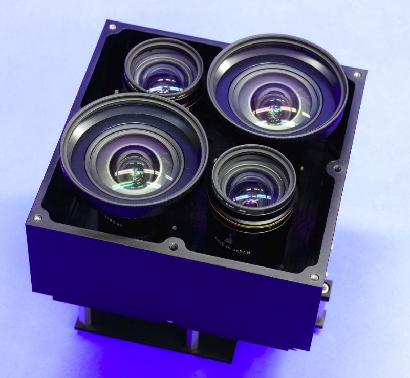
The WNISAT-1R mission features a number of improvements and additions over the original microsatellite mission, expanding the satellite’s payload suite to collect additional data on sea states and weather. WNISAT-1R carries a much improved camera package using four cameras to collect data in the visible and near-infrared ranges, and a GNSS Reflectometry payload for land and ocean property measurements.
WNISAT-1R hosts four separate camera assemblies: a panchromatic imaging system sensitive in the 450-650-nanometer band, green (535-607nm) and red (620-680nm) cameras and a near-infrared imager (695-1005nm). All cameras use identical detectors with 2048 x 2048 pixels and a 12-bit read out; the NIR & Red camera achieve a 400-meter ground resolution across an 800-Kilometer swath while the Green & PAN cameras reach a 200-meter resolution across a 400km swath.
The WNISAT camera suite is primarily in charge of collecting information on sea states and pack ice movement through the Arctic waters as well as stereo-imaging for cloud height measurements and adverse weather monitoring.
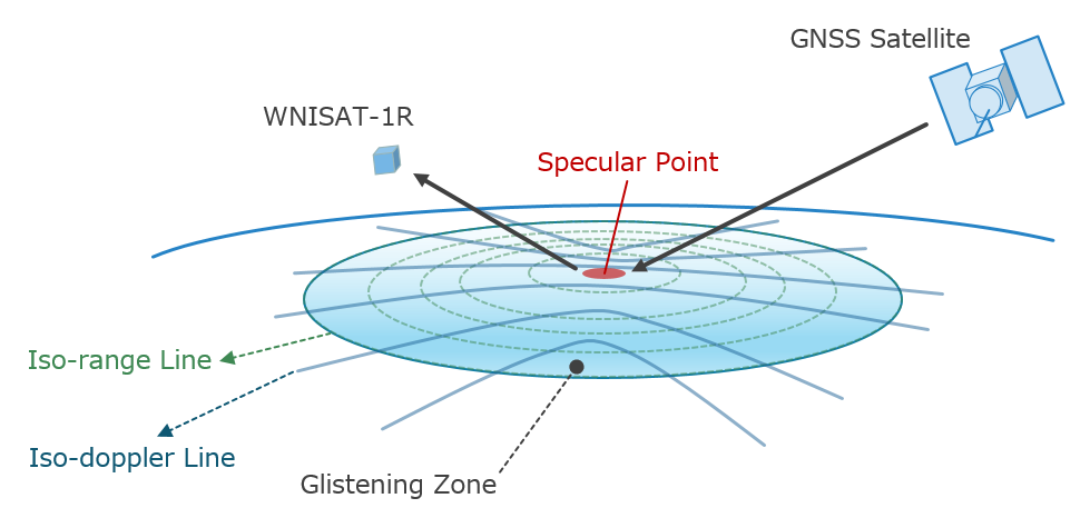
WNISAT-1R hosts a Global Navigation Satellite System Reflectometry instrument exploiting GPS signals reflected from Earth’s surface to extract land and sea surface properties relevant for safety analysis concerning ship traffic through the arctic region.
GPS operates a constellation of approximately 30 active satellites in six orbital planes, 20,000 Kilometers in altitude, transmitting different L-Band signals used for navigation and precise timing applications as well as a wide variety of other applications including meteorology. At least four satellites are simultaneously visible from any position on Earth.
Reflectometry of GNSS signals (using Earth-reflected GNSS signals to obtain information on land & ocean properties) has been proposed in the late 1980s for ocean sensing and in 1993 for ocean altimetry with first tests carried out in the early 2000s. After initial proof-of-concept missions, small GPS reflectometry instruments were developed and the method is now used for remote-sensing with particular focus on ocean surface properties like temperature and wind speed (see NASA’s CYGNSS Mission).

GNSS-R instruments are attractive solutions for all-weather, day & night data collection via small satellite missions. Cameras are dependent on daylight and cloud-free conditions while other instruments like radars and radiometers do not yet comply with the restrictions of a small satellite mission (power, instrument size). No details on the specifications of the WNISAT GNSS-R instrument are available other than that the GNSS-R patch antenna on the satellite was provided by Weathernews while Axelspace developed the signal processing technology that records, amplifies and processes the weak GPS backscatter signals.
A secondary payload carried by WNISAT-1R is a Laser Communications Terminal suitable for a small satellite mission, promising to allow for low-cost high-data rate communications for future operational missions.