
Kanopus-V No. 3 & 4
Kanopus-V 3 and 4 are the third and fourth members of Russia’s Kanopus-V Remote Earth Sensing Satellite carrying a multi-instrument package for high-resolution imaging, color imaging, and multi-spectral data collection for environmental monitoring, mapping, fire detection, agricultural planning, land use assessments, and urban planning.
Kanopus builds a constellation of small remote sensing spacecraft, operating alongside the large Resurs satellites that build Russia’s primary civilian Earth observation system, however, both Resurs and Kanopus have some overlap with the military and will be called upon when necessary to deliver data for defence ministry purposes.
The Kanopus Program is operated by Roscosmos and data users include the Ministry of the Russian Federation for Civil Defense, Emergencies and Elimination of Consequences of Natural Disasters, Ministry of Natural Resources of the Russian Federation, the Federal Service for Hydrometeorology and Environmental Monitoring, and the Russian Academy of Sciences.
The first Kanopus-V (Kanopus Vulkan) satellite was launched in July 2012. Designated Kanopus-V 1, the satellite had a launch mass of 475 Kilograms and was based on the Kanopus satellite platform, designed specifically for the program. The satellite hosts a panchromatic imaging system achieving a 2.5-meter ground resolution, a full color imaging system with a 12-meter resolution and a multi-spectral imager achieving a 25-meter resolution. Built for a five-year service life, Kanopus-V 1 remained operational through 2017.
Kanopus ST-1 carried specialized equipment for ocean and weather research, hosting a microwave radiometer and multispectral camera. Built with Defence Ministry funds, Kanopus-ST was reportedly capable of scanning underwater areas for submarines. The craft launched atop the second Soyuz 2-1v rocket and achieved the planned orbit, but failed to separate from the upper stage due to a malfunction of the separation mechanism. The upper stage-satellite stack re-entered only a few days after launch, rendering the mission a complete loss.
Kanopus V-IK started out as Kanopus V No. 2 in 2011 but was delayed by six years to facilitate its conversion to Kanopus V-IK through the addition of the MSU-IK-SRM infrared-sensing instrument for hot-spot and fire detection. (IK being an abbreviation for Infra-Krasny (=infrared).
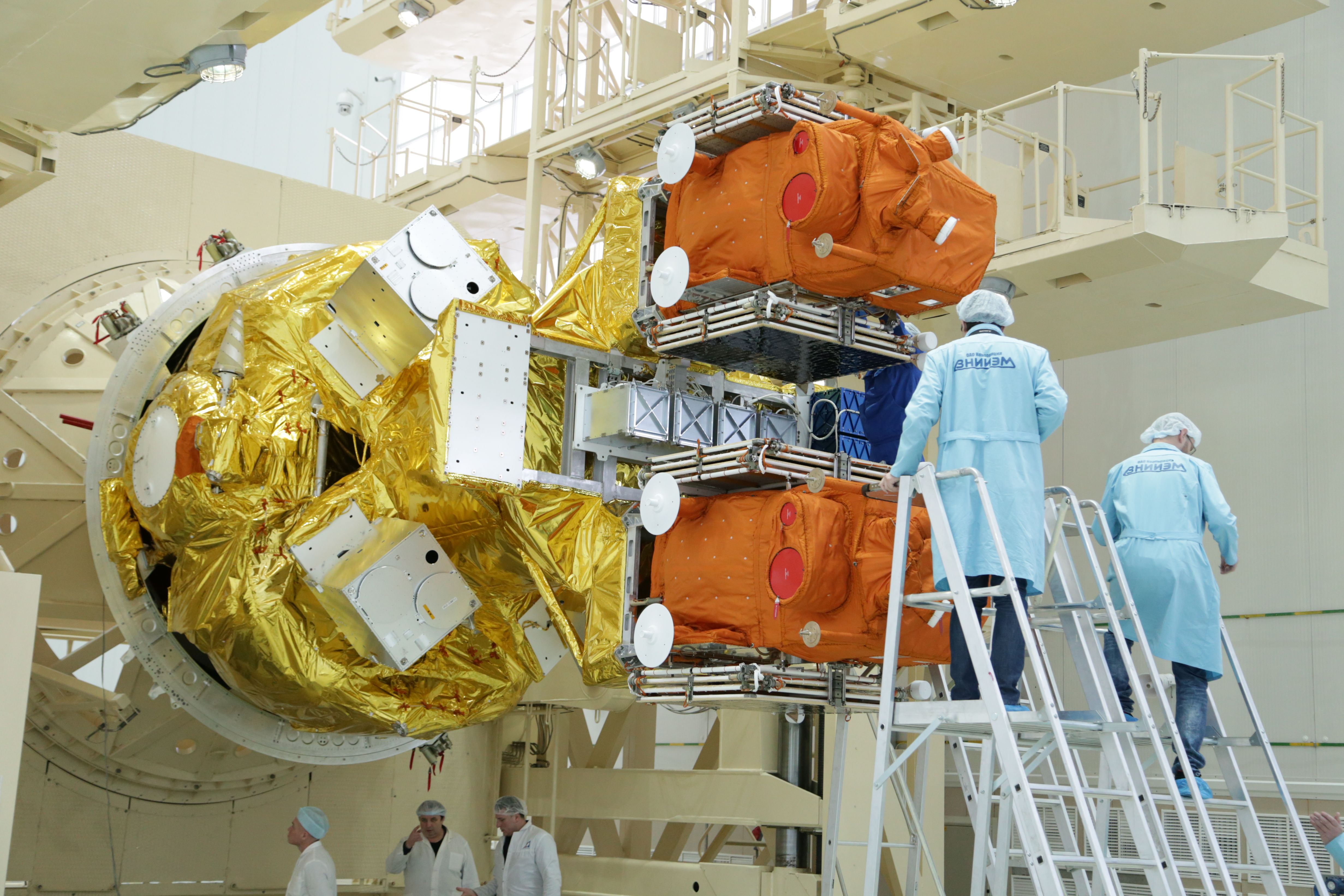
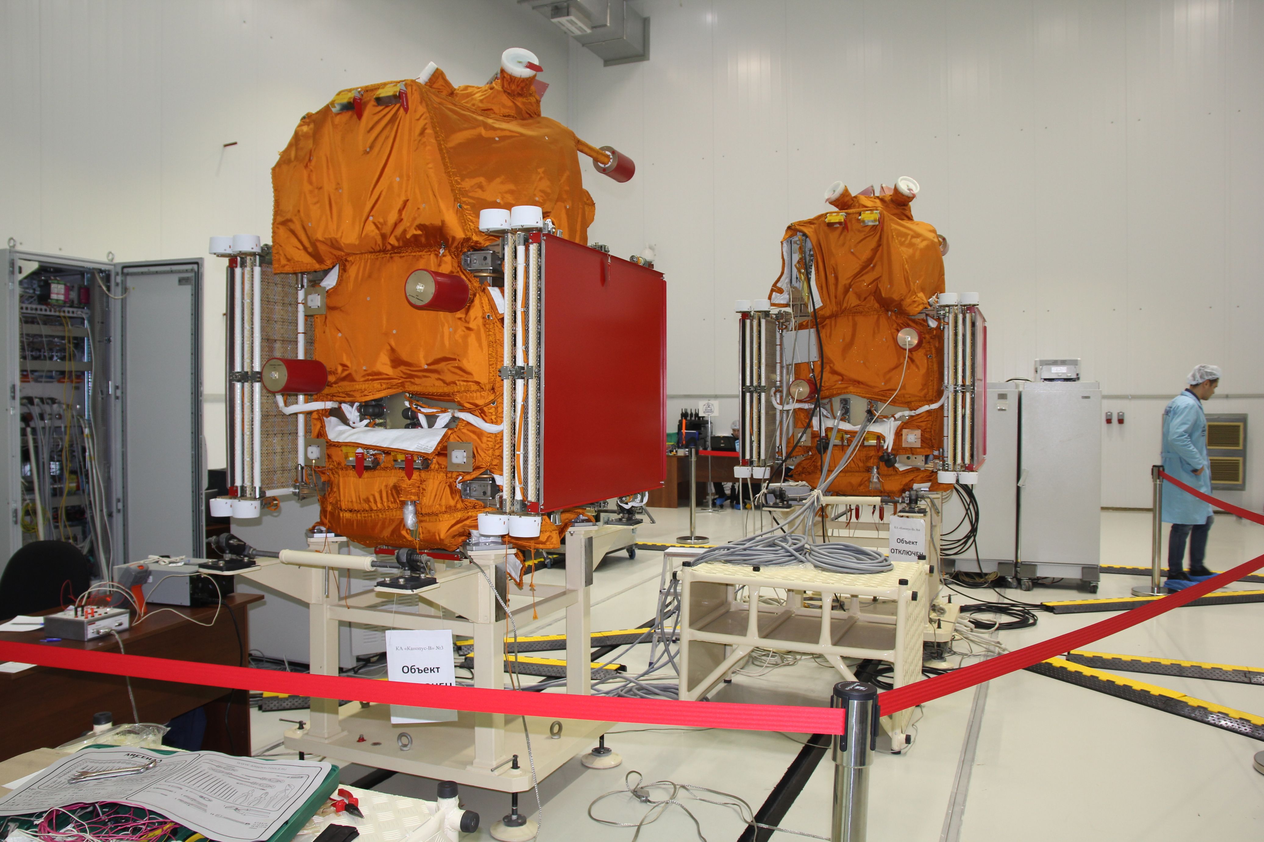
The Kanopus-V 3 and 4 satellites are launching side-by-side atop a Soyuz rocket in 2018 from Russia’s Vostochny Cosmodrome and will therefore enter the same orbital plane and will be followed by the Kanopus-V 5 and 6 pair later in 2018 – likely setting up a two-plane constellation with morning and afternoon viewing capability.
Contracted for the development of the Kanopus satellites, Russian company NPP VNIIEM elected to work with Surrey Satellite Technology Ltd. based in the United Kingdom given their experience with small satellites. Under the contract signed in 2007, SSTL is delivering three suites of satellite avionics and software plus technical support, electrical power management and batteries, onboard computers and data handling systems. The company will also provide spacecraft assembly and integration support.
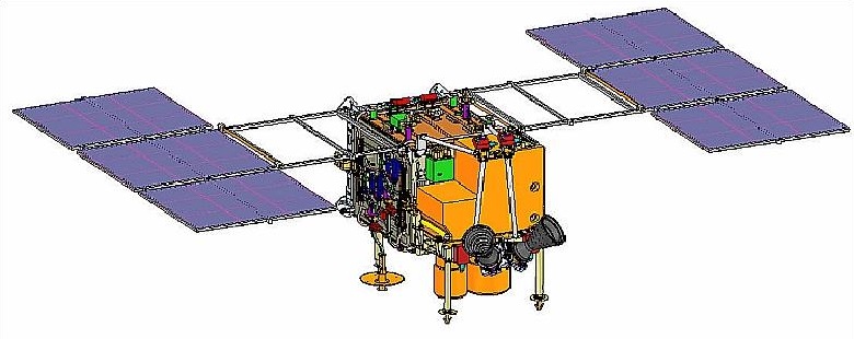
According to VNIIEM, the Kanopus-V satellites are largely identical with no significant changes from the satellite launched in 2012 to the satellites launching in 2018 in terms of platform design as well as instrument capabilities. Each weighs in at 490 Kilograms and hosts a payload of 106 Kilograms.
The Kanopus satellite bus hosts a pair of deployable solar arrays, each comprised of three panels for a total orbit average power supply of 300 Watts. The spacecraft host precise attitude determination and control systems featuring star trackers, sun sensors, and inertial measurement systems for attitude determination and reaction wheels as primary attitude actuators.
The satellite platform supports precise pointing with an attitude stability of 0.001 degrees per second and a pointing accuracy of 5 arcmin. Imaging at off-nadir angles up to +/-40 degrees can be supported, requiring 2 minutes for a slew from –40° to +40° off-nadir, allowing the satellite to conduct agile imaging operations with quick re-targeting. An onboard GNSS navigation receiver provides the satellite’s position with an accuracy of 15 meters for proper geo-tagging of acquired imagery.
The Kanopus satellites have an onboard memory of 24 gigabytes; data downlink is accomplished using an X-Band communications system operating between 8.048 and 8.382 GHz and achieving data rates up to 122.8 Megabits per second.
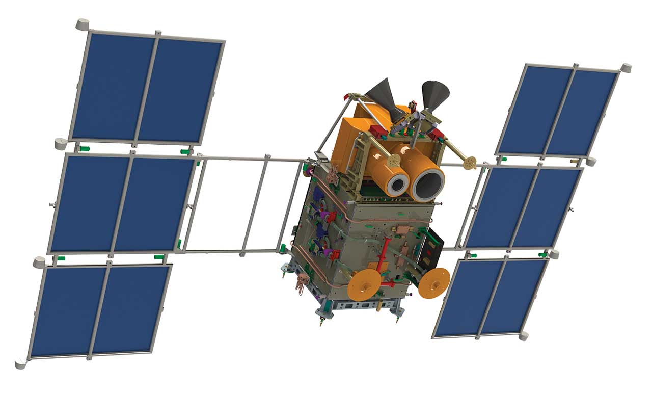
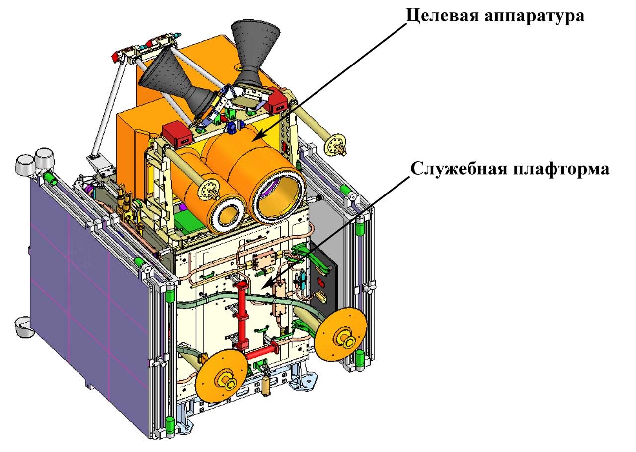
Kanopus-V 3 and 4 each carry two instruments, the Panchromatic Imaging System PSS and the Multispectral Imaging System MSS.
PSS, the Panchromatic Imaging System, has the objective of collecting black-and-white imagery at medium to high resolution for environmental monitoring, agriculture, forestry and disaster monitoring. The single-channel instrument hosts a telescope with a 179.75-centimeter focal length, feeding a focal plane with a 1920 by 985-pixel detector, sensitive in the wavelength range of 520 to 850 nanometers. PSS covers a ground swath of 23.3 Kilometers and achieves a resolution of 2.1-meters for nadir imagery.

The MSS Multispectral Imaging System hosts a 35.95-centimeter telescope feeding a 1920 x 985-pixel detector array covering four spectral bands: 460-520, 510-600, 630-690, and 750-840 nanometers, extending from the green wavelengths relevant for vegetation assessments into the red spectrum and into the near infrared. MSS also covers a 23-Kilometer ground swath and its ground resolution reaches 10.5 meters at nadir.
The Kanopus V-IK satellite operates from a Sun Synchronous Orbit 510 Kilometers in altitude at an inclination of 97.4 degrees, with a period of 94.8 minutes. A total of six Kanopus V satellites are targeting launch by 2019 to establish a constellation of small remote sensing satellites for responsive data collection and rapid revisit time across the globe.
