
LAPAN A3
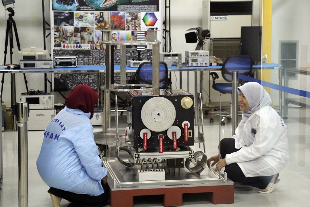
LAPAN-A3 is a microsatellite developed at the Indonesian National Institute of Aeronautics and Space. It is a sister of the LAPAN-A2 satellite launched on the PSLV C30 mission with many systems shared by the two spacecraft.
he satellite is based on the 2007 LAPAN-TUBSAT microsatellite project – a partnership between Indonesia and the Technical University of Berlin that was used to train LAPAN engineering staff in the development, manufacture and conduct of a microsatellite space mission.
The objectives of the LAPAN-A3 mission are threefold – the satellite aims to deliver high-resolution imagery for Earth Observation Purposes, support the Automatic Packet Reporting System as a voice repeater in disaster mitigation, and collect Automatic Identification System data for maritime monitoring. Furthermore, the satellite also acts as a technical demonstrator testing a series of new space systems for future Indonesian satellite developments.


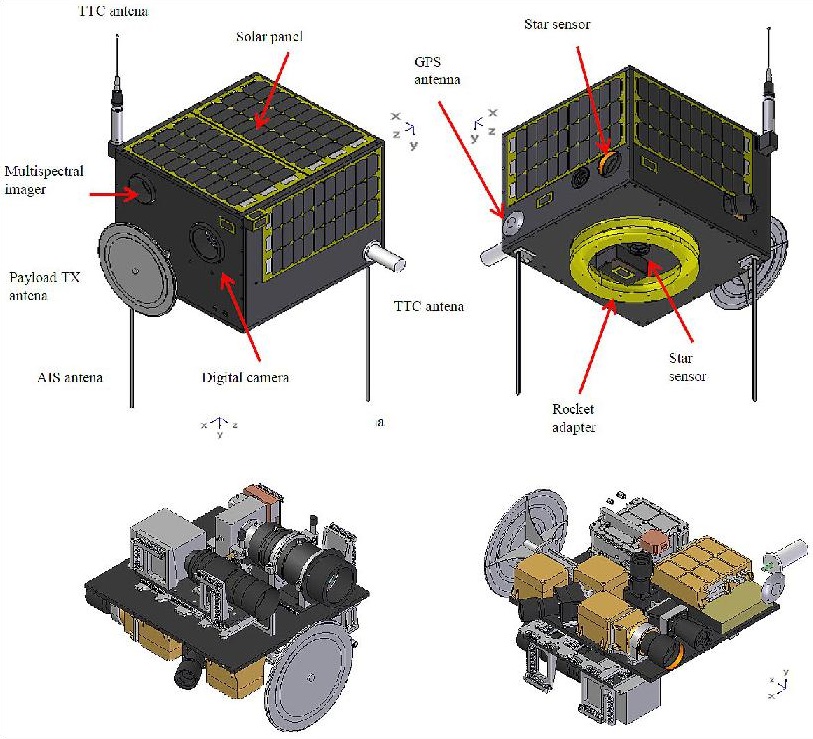
LAPAN-A3 has a mass of 115 Kilograms and is 50 by 57 and 42 centimeters in size. An internal divider creates two shelves within the satellite to facilitate the various bus and payload components. The upper compartment is larger than the lower and facilitates bigger components such as the imaging payload and satellite batteries while the smaller components such as the electronics reside within the lower shelf.
The satellite employs body mounted triple-junction Gallium-Arsenide Solar Cells attached to five external panels of the satellite. Each solar panel is 47 by 26 centimeters in size and holds 30 cells for a maximum power generation of 37 Watts. Power is stored in three Li-Ion batteries that are arranged in parallel, each with four cells per pack connected in series. The total storage capability is 17 Amp-hours and the power conditioning and distribution system delivers a stable bus voltage of 15 Volts.
The LAPAN-A3 Attitude Determination and Control System builds on that of the first generation satellite, but expands the base system by adding GPS receivers and a more complex attitude control system to increase the pointing accuracy of the satellite.
Three pairs of reaction wheels are the primary source of attitude actuation with three magnetic torquers used for momentum dumps from the wheels as well as drift correction. Coarse attitude determination is delivered by six sun sensors and a series of gyros can be used to precisely measure the three-axis rates on the satellite. When precision control is needed, LAPAN-A3 uses data delivered by two Star Trackers, one using a CCD while the other employs a CMOS detector.
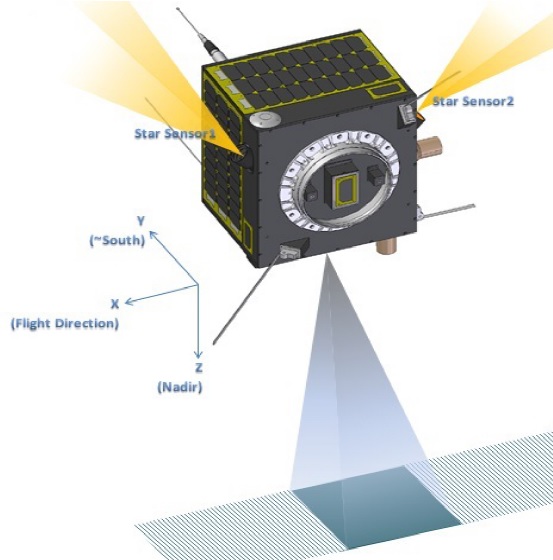
The working principle of the two star trackers is identical – capturing images of the sky for comparison with known star patterns in an algorithm that delivers precise attitude data to the spacecraft controllers. The CMOS-based sensor has a field of view of 14 by 14 degrees and delivers four attitude quartenions per second while the CCD system has a wider field of view of 31 by 23° and outputs five data sets per second.
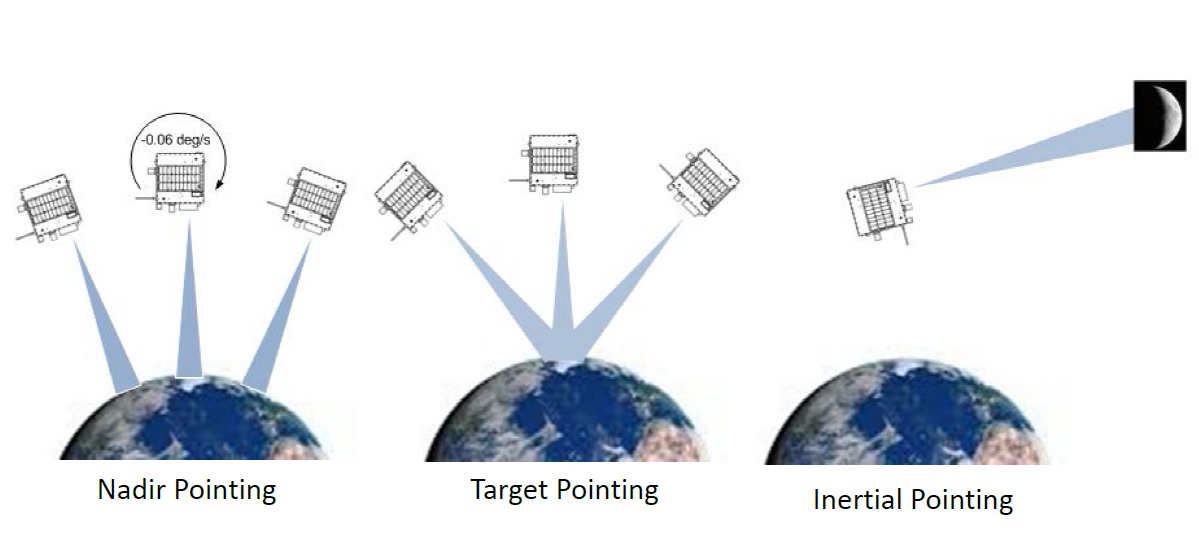
The LAPAN-A3 satellite is capable of operating in a number of attitude modes, such as a constant nadir-pointing orientation to face the imaging system nadir along the ground track. Off-nadir pointing and target pointing is also possible with target pointing used to keep a selected target within the field of view for a period of time while video of it is acquired for stereoscopic imaging. Inertial pointing in which the camera is pointed to a celestial target in space is also available.
LAPAN-A3 can use an automatic capturing sequence which will become the operational mission mode after in-orbit testing is complete. The spacecraft controller uses inputs from the star trackers and gyros for precise attitude and rates as well as the GPS receivers for position and timing solutions to generate commands to the attitude control actuators in a closed-loop process to point the satellite to the appropriate direction where the target is located. Target pointing up to +/-30° in the pitch and yaw axes can be supported by the satellite.
Communications are accomplished in UHF X- and S-Band – UHF is used for telemetry downlink and command uplink at th 437MHz frequency, while payload data is transmitted to Earth using an S-Band system at 2.2GHz. X-Band is used for high-data rate downlink of Earth imaging data at 105 Mbit/s with the system operating at 8.2GHz.
The LAPAN A3 satellite carries a package of three payloads – a Multispectral Imager, A Digital Space Camera and and Automatic Identification System Receiver (AIS). The Payload Data Handling System operates at data rates up to 200Mbit/s and includes 16Gbit of memory.
The Multispectral Imager is a pushbroom imaging system covering four spectral bands to deliver environmental observations. The camera has a 300-millimeter lens focusing an image onto a four-line detector with 8002 pixels per line. The following wavelength ranges are covered by the instrument: 450-520 nanometers (blue), 520-600nm (green), 630-690nm (red) and 760-900nm (near infrared). MSI covers a 100-Kilometer ground swath and achieves a ground resolution of 19 meters.
The Digital Space Camera has a 1,000mm lens and features a two-dimensional pixel array detector comprised of 2000 by 2000 pixels. DSC covers a 10-Kilometer swath at a high resolution of 5 meters, only collecting panchromatic imagery.
Given the vast stretches of territorial water belonging to Indonesia, the addition of an Automatic Identification System payload to the LAPAN-A3 satellite was a requirement introduced early in the mission planning.
The Automatic Identification System is used by sea vessels that send and receive VHF messages containing identification, position, course and speed information to allow the monitoring of vessel movements and collision avoidance as well as alerting in the event of sudden speed changes.
These signals can be transmitted from ship-to-ship and ship-to-shore to allow the monitoring of a local area, but deploying space-based AIS terminals allows a broad coverage and data relay to ground stations for monitoring of large sea areas. However, due to the large footprint of satellites, overlapping and signal collisions become a problem, especially for frequented traffic routes.
LAPAN-A3 carries a single AIS antenna and receiver capable of receiving multiple parallel signals in any of the two channels in the maritime VHF band.