
CYGNSS – Cyclone Global Navigation Satellite Mission

CYGNSS – the Cyclone Global Navigation Satellite Mission, is a multi-satellite mission operated by NASA to establish a space-based system for the study of the interaction between the sea and air near the core of tropical storms with the goal of improving extreme weather predictions. Eight CYGNSS satellites are launched on a single Pegasus Rocket and employ a scatterometry technique that extracts information on the wind conditions over the ocean surface from scattered GPS signals, a technique only recently developed for use in operational and scientific applications.
>>Orbit Design & Ground Segment
The goal of the eight CYGNSS satellites is to remain active for two hurricane seasons, building a constellation in a non-synchronous orbit to deliver high-revisit rates with measurements of any storm every six hours – also enabling the mission to support operational hurricane forecasting by delivering ocean surface wind speed products to weather forecasters.


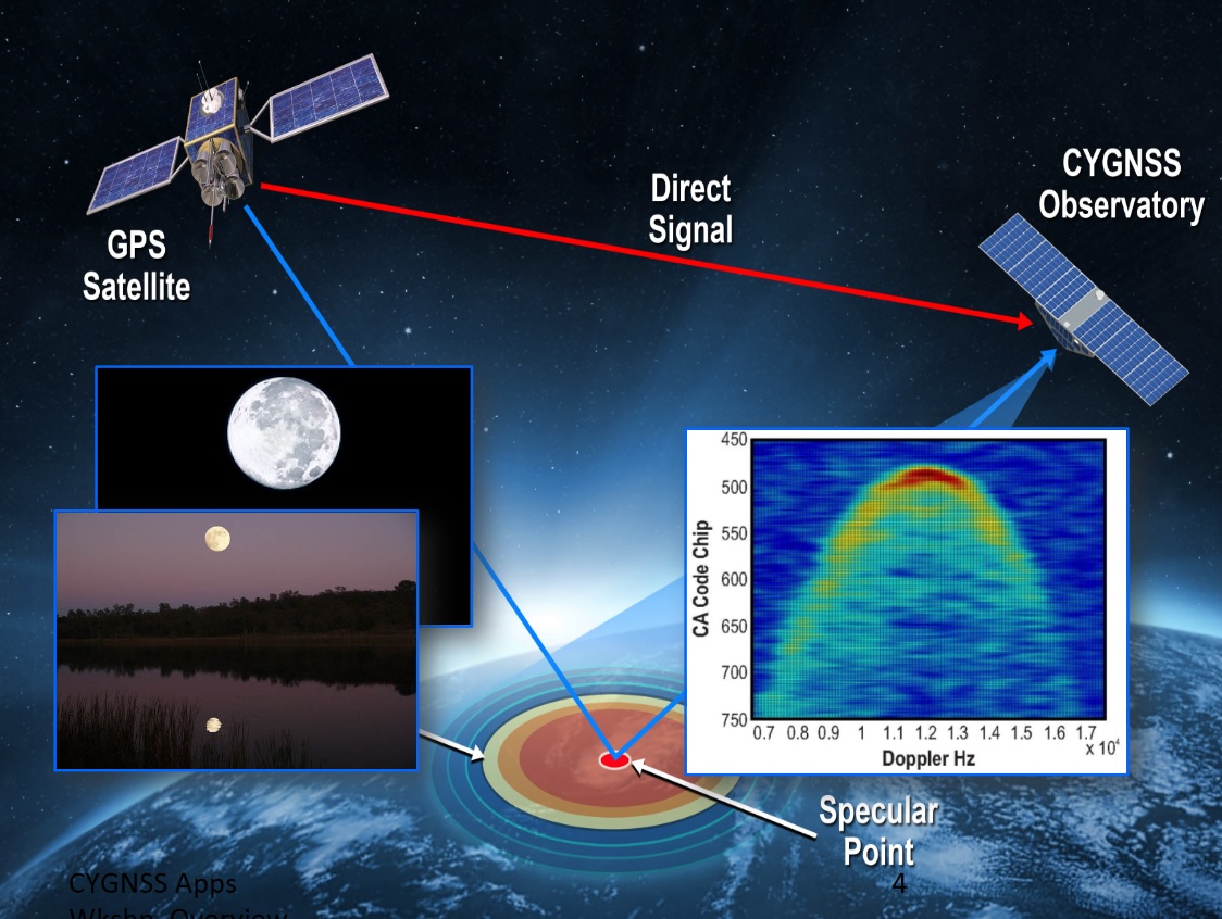
The measurement conducted by CYGNSS is known as bi-static scatterometry and requires the satellite to receive a direct signal from a GPS satellite which pin-points the CYGNSS satellite’s position & provides a timing reference, and also detect the same signal after it is reflected from the Earth.
These reflected, or scattered signals deliver information on sea surface roughness which corresponds to wind speed over the ocean surface. GPS-based scatterometry is possible in all weather conditions and the signals penetrate even the most dense rain bands that prevent conventional sensors from studying storm core dynamics.
Science goals addressed by the CYGNSS mission are to further the current understanding of the coupling between ocean surface properties, atmospheric thermodynamics, radiation and convective processes in the inner core of a tropical cyclone. Measurements of ocean winds are made in all precipitating conditions including the eyewall of a tropical storm.
With a constellation of eight satellites, CYGNSS will be able to help understand processes in the genesis and rapid intensification of storm systems. This will ultimately yield better storm intensity forecasts which, in recent decades, have lacked improvement while other areas such as storm track forecasting showed considerable improvements since the start of the millennium.
The measurements CYGNSS aims to deliver need to be made by a specialized spaceborne sensor suite because current ground and space based sensors are unable to deliver the required data from the inner cores of storms due to obscuration by dense rain bands and infrequent sampling by wide-swath instruments of conventional polar-orbiting spacecraft.
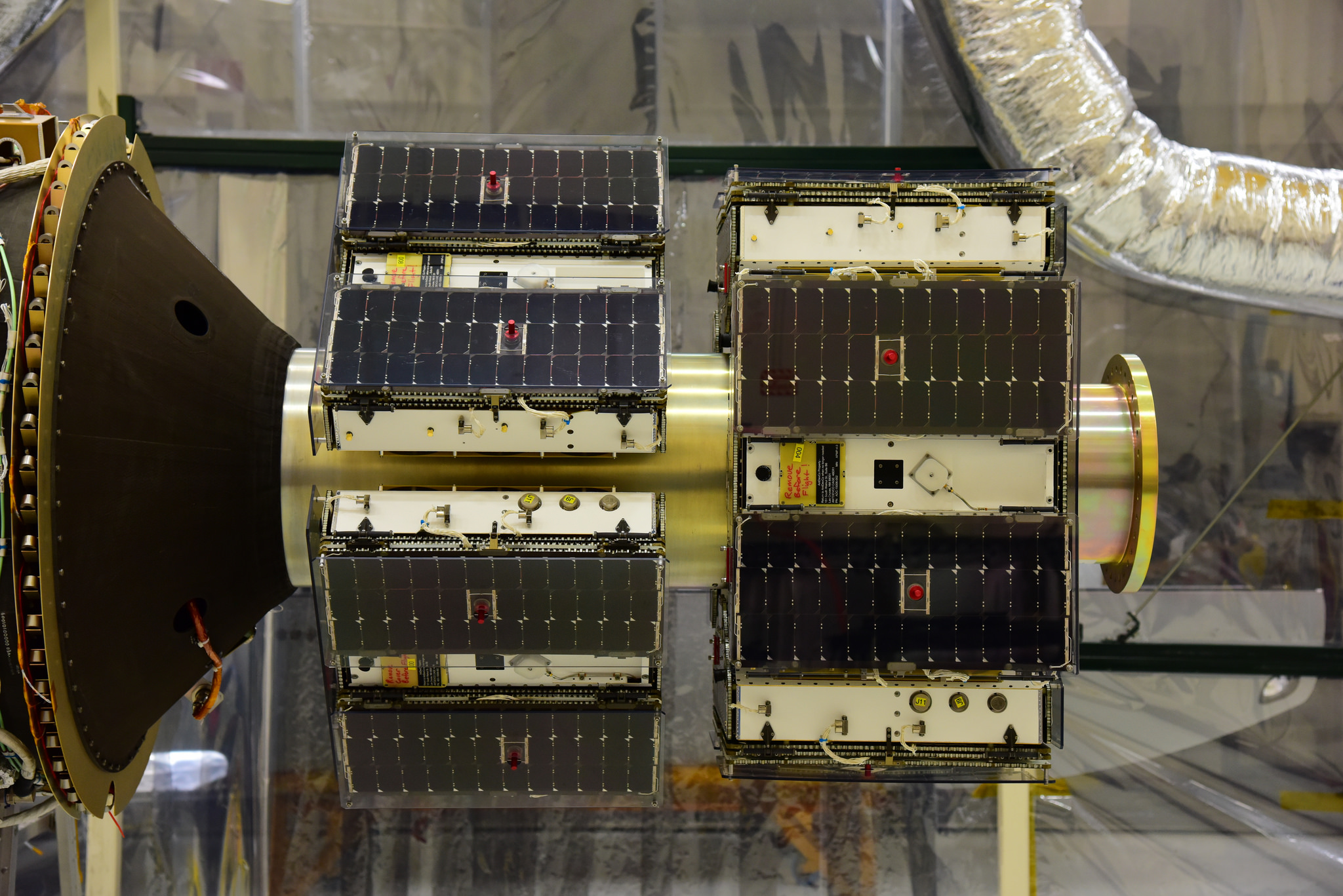
NASA selected the CYGNSS mission in 2012 as the first in the Venture-Class spaceborne missions under the Earth System Science Pathfinder Program. The mission has a budget of $152 million with the Southwest Research Institute and University of Michigan in charge of satellite development and operation, the U.S. subsidiary of the UK-based company SSTL is responsible for the GPS receivers installed on the satellites and Sierra Nevada Corporation provides the satellite deployment module.
A constellation of microsatellites was chosen for the CYGNSS mission for a number of reasons – a) because the primary instrument of the spacecraft fits within the restrictions imposed by microsatellite platforms (size, power, data volume), b) because a number of spacecraft are needed to establish the desired revisit time and c) to comply with the mission’s budget for satellite development & manufacture as well as launch vehicle procurement.
Each CYGNSS satellite consists of a microsatellite platform developed by SwRI and a GPS receiver capable of simultaneously tracking scattered signals from four different GPS satellites – meaning CYGNSS collects 32 wind measurements per second across the globe. This results in a close cross-hatch of sample points on the ground in a latitude band of +/-35 degrees with an average revisit time around four to six hours – permitting measurements of rapid storm dynamics such as intensification processes.